
Karimnagar (District)
| Karimnagar | |
|---|---|

|
|
| State | Telangana |
| Administrative headquarters : | Karimnagar |
| Area : | 11,823 km² |
| Residents : | 3,811,738 (2011) |
| Population density : | 322.4 inhabitants / km² |
| Website : | Official website of the district |
Karimnagar ( Telugu : కరీంనగర్ జిల్లా, Urdu : کریم نگر ضلع) is a district in the Indian state of Telangana . The main town of the district is Karimnagar .
History and creation
Karimnagar district was named after Syed Karimullah Shah Sehab Quiladar. The current district has only existed in this form since the British colonial era, more precisely since 1906. In the past, individual areas were under the rule of several different dynasties at different times.
geography
The district is in the north of Telangana . It is framed in the north by the Adilabad district , in the northeast by the states of Maharashtra and Chhattisgarh , in the south by the Warangal district , in the southwest by the Medak district and in the west by the Nizamabad district .
The district has an area of 11,823 km 2, making it the twelfth largest district in Andhra Pradesh (4.3 percent of Andhra Pradesh). Of the area, 2,545 km 2 (21.5 percent) are forested.
The Eastern Ghats cross the district in the northwest. Another ridge is located in the southeast of the district. Otherwise it is largely flat.
The main river that drains the district is the Godavari River . It forms a natural border in the north and east of the district. Another important river is the Manair .
climate
The climate is divided into four seasons. March to May is summer time with great drought and high temperatures. The southwest monsoon from June to early September brings the most abundant rain. The northeast monsoon brings slightly lower but still significant amounts of rain. The amount of precipitation increases in the district from the southwest to the northeast. Winter is in the months of January and February with slightly cooler temperatures. The long-term average of rainfall in the district is 920 mm per year. The southwest monsoon brings 756 mm and the northeast monsoon 101 mm of the annual rainfall. Otherwise there will be little rain. This leads to the drying up of the cultivated areas in the dry season, which lasts from January to May. The coldest month is December (average 21.24 ° - daily minimum 15 °, maximum 28 °), the warmest May (average 33.38 ° - minimum 27 °, maximum 40 °). During the Mosun season there is a humidity of up to 80 percent. This falls to 30 percent in the dry period.
population
The last census in 2011 counted 3,811,738 inhabitants. 1,897,068 of these were men (49.8 percent) and 1,914,670 women. In 2001 the Dalit numbered 650,246 (18.6 percent) and the Adivasi 90,636 (2.6 percent) people. Of the total number of residents, 994,231 people (26.08 percent) lived in urban areas in 2011. Thus around 3 out of 4 inhabitants still lived in the country. The majority of the population of Karimnagar District speaks Telugu . There are 1,047 inhabited villages in the entire district.
Population of the district by confession
The residents are almost entirely Hindu. The only significant religious minority are the Muslims with around 6 percent of the population. Smaller minorities are Christians and Sikhs. The following table shows the exact religious composition of the population:
| year | Buddhists | Christians | Hindus | Jainas | Muslims | Sikhs | Other | not specified | Total | |||||||||
|---|---|---|---|---|---|---|---|---|---|---|---|---|---|---|---|---|---|---|
| number | % | number | % | number | % | number | % | number | % | number | % | number | % | number | % | number | % | |
| 2001 | 122 | 0.00% | 20,576 | 0.59% | 3,251,834 | 93.13% | 81 | 0.00% | 213.811 | 6.12% | 1,962 | 0.06% | 312 | 0.01% | 3.124 | 0.09% | 3,491,822 | 100.00% |
| Source: 2001 India Census | ||||||||||||||||||
Population development
As everywhere in India, the population in the Karimnagar district has been growing rapidly for decades. Although the increase in the years 2001–2011 was only below 10 percent (9.16%), it is still significant in absolute terms. From 2001 to 2011 the population still increased by over 300,000 people. The following table shows the exact numbers:

Significant places
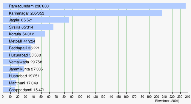
The most populous town in the district is Ramagundam . Behind it follows the main town Karimnagar . Other important cities with over 50,000 inhabitants are Jagtial , Sirsilla and Koratla .
administration
The Karimnagar district comprises 57 mandals (talukas) and 1047 inhabited villages. There are 6 independent parishes in the district.
The district is also divided into 5 districts. These are:
- Jagtial
- Karimnagar
- Manthani
- Peddapalli
- Sirsilla
Web links
- Karimnagar District official website
- The Karimnagar District on Glorious India
- general information about the district
- More information about the district
- Precipitation levels 2006-2010
- District map
- Map of the main streets of the district
- Map of the rivers
- Map of the rivers
- Map of the railway lines
- another map of the district
- First results of the 2011 census
Individual evidence
- ↑ Archived copy ( Memento of the original from May 18, 2012 in the Internet Archive ) Info: The archive link was inserted automatically and has not yet been checked. Please check the original and archive link according to the instructions and then remove this notice.
- ↑ Administrative areas of India (PDF; 399 kB)
- ↑ Forest Report, page 3 ( Memento of the original from October 24, 2013 in the Internet Archive ) Info: The archive link was inserted automatically and has not yet been checked. Please check the original and archive link according to the instructions and then remove this notice. (PDF; 7.6 MB)
- ↑ Climate in the main town
- ↑ Climate-average rainfall, page 1 ( Memento of the original from March 18, 2013 in the Internet Archive ) Info: The archive link was inserted automatically and has not yet been checked. Please check the original and archive link according to the instructions and then remove this notice. (PDF; 431 kB)
- ↑ Data on the climate
- ↑ Information on climate and water ( Memento of the original dated May 2, 2012 in the Internet Archive ) Info: The archive link was inserted automatically and has not yet been checked. Please check the original and archive link according to the instructions and then remove this notice. (PDF; 1.5 MB)
- ↑ Census of India 2001, Karimnagar District (PDF; 55 kB)
- ↑ AP Online: Karimnagar District ( Memento of the original from March 14, 2012 in the Internet Archive ) Info: The archive link was inserted automatically and has not yet been checked. Please check the original and archive link according to the instructions and then remove this notice.

Districts as of 2016 (31 districts)
Adilabad |
Bhadradri Kothagudem |
Hyderabad |
Jagtial |
Jangaon |
Jayashankar Bhupalapally |
Jogulamba Gadwal |
Kamareddy |
Karimnagar |
Khammam |
Kumaram Bheem |
Mahabubabad |
Mahabubnagar |
Mancherial |
Medak |
Medchal – Malkajgiri |
Nagarkurnool |
Nalgonda |
Nirmal |
Nizamabad |
Peddapalli |
Rajanna Sircilla |
Rangareddy |
Sangareddy |
Siddipet |
Suryapet |
Vikarabad |
Wanaparthy |
Warangal Rural |
Warangal Urban |
Yadadri Bhuvanagiri
districts until 2016 (10 districts)
Adilabad |
Hyderabad |
Karimnagar |
Khammam |
Mahbubnagar |
Medak |
Nalgonda |
Nizamabad |
Rangareddy |
Warangal