
Primosten
| Primosten | |||
|
|||
|
|||
| Basic data | |||
|---|---|---|---|
| State : |
|
||
| County : |
|
||
| Height : | 0 m. i. J. | ||
| Area : | 57.18 km² | ||
| Residents : | 2,828 (2011) | ||
| Population density : | 49 inhabitants per km² | ||
| Telephone code : | (+385) 022 | ||
| Postal code : | 22 202 | ||
| License plate : | ŠI | ||
| Boat registration : | PS | ||
| Structure and administration (status: 2013, cf. ) |
|||
| Community type : | local community | ||
| Mayor : | Stipe Petrina (independent) | ||
| Website : | |||


Primošten [ ˈprimɔʃtɛn ] (German outdated: Groß Kap-Zesto , Italian: Capocesto ) is a municipality in Croatia .
Location and inhabitants
Primošten is located in central Dalmatia about 60 kilometers north of Split and about 30 kilometers south of Šibenik on the Adriatic coast. The municipality consists of six villages and hamlets and has 2,828 inhabitants (2011), 1,631 of which live in the main town of Primošten.
economy
The former fishing village with its old town (Raduča) located on a peninsula is now a popular tourist and holiday destination in Dalmatia . Primošten has been developed for tourism since 1960.
The inhabitants live mainly from tourism , fishing and wine and olive growing. The red wine Babić is known in the region .
history
Primošten was originally a small island in close proximity to the mainland. Initially the place was connected to the mainland by a mobile bridge, later the bridge was replaced by a dike. Therefore, the place got its current name in 1564 after the verb primostiti , which means "to bridge". At the highest point of the peninsula is the parish church of Sv. Juraj (St. George). The place is surrounded by the city wall built in the 17th century . Seafarers often called the place "the dry cape" because of the long periods of drought that prevail here.
Culture
Primoštenske užance take place in summer .

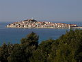
Primošten, looking south

Primošten, at the harbor
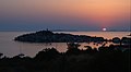
Sunset in Primošten

Alley in Primošten
Primošten, looking north

Maria von Loreto - Monument on a mountain near Primošten


Web links