Prunéřovský potok
|
Prunéřovský potok Brunnersdorfer Bach |
||
| Data | ||
| Water code | CZ : 1-13-02-109 | |
| location | Czech Republic | |
| River system | Elbe | |
| Drain over | Eger → Elbe → North Sea | |
| origin | at Výsluní 50 ° 29 ′ 20 ″ N , 13 ° 11 ′ 21 ″ E |
|
| Source height | approx. 897 m | |
| muzzle | at Kadaň in the Eger coordinates: 50 ° 22 ′ 48 ″ N , 13 ° 14 ′ 57 ″ E 50 ° 22 ′ 48 ″ N , 13 ° 14 ′ 57 ″ E |
|
| Mouth height | approx. 285 m | |
| Height difference | approx. 612 m | |
| Bottom slope | approx. 25 ‰ | |
| length | 24.7 km | |
| Catchment area | 54.7 km² | |
The Prunéřovský potok (German Brunnersdorfer Bach , formerly also Wistritzer Bach , rarely Pressnitzer Bach , Turtschinkenbach ) is a left tributary of the Eger in the Czech Republic .
course
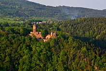
The creek originates near the Erzgebirgs - ridgeline in the nature reserve Prameniště Chomutovky northwest of Výsluní (Sonnenberg). This is also where the Chomutovka and the Black Pockau (Černá) flow north . First it runs in a south-easterly direction towards Výsluní, where it suddenly turns north-east and follows the direction of the Ore Mountains. It follows this direction, which is unusual for the Bohemian Ore Mountains, for almost 2.5 km, and after a breakthrough near Celná for about 4.5 km, it takes the opposite direction to the southwest. Here the brook has cut a steep, rocky valley up to 150 m deep. After it has taken up the Třebíšský potok (Triebischler stream) from the right , it flows in a curved, deep valley, past the Hasištejn castle , towards the edge of the Ore Mountains. There it is crossed by the water supply system Podkrušnohorský přivaděč , which connects the two rivers Eger and Bílina . The original course led the stream in a straight line via Bystřice (Wistritz) and Kadaň (Kaaden) into the Eger. In the second half of the 20th century he had the lignite - opencast mine Nástup Tušimice- and the power plant Tušimice soft; its lower course was led around this and relocated to the west. Today it flows into the Kadaň dam about 2 km further west .
Tributaries
- Šebestiánka (l)
- Výslunský potok (r)
- Zvonící potok (r)
- Třebíšský potok (Triebischler Bach) (r)
- Trntý potok (r)
particularities
The brook and its side valleys are extensively protected as the Údolí Pruneřovskeho Potoka Nature Park between Vysluni and the exit from the Ore Mountains . In a side valley is the 25 m high waterfall Kýšovický vodopád .
Individual evidence
- ^ Johann Gottfried Sommer : The Kingdom of Bohemia; Represented statistically and topographically . tape 14 . Saaz circle. Ehrlich, Prague 1846, p. 179 ( online ).
- ↑ The Brunnersdorfer Bach. (No longer available online.) Formerly in the original ; Retrieved December 11, 2014 . ( Page no longer available , search in web archives ) Info: The link was automatically marked as defective. Please check the link according to the instructions and then remove this notice.
- ^ Prunéřovské údolí valley. Retrieved December 11, 2014 .
- ^ Kýšovický vodopád. Retrieved December 11, 2014 .


