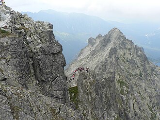
Przełęcz pod Rysami
| Przełęcz pod Rysami | |||
|---|---|---|---|
|
Pass from the top of Rysy |
|||
| Compass direction | west | east | |
| Pass height | 2365 m npm | ||
| Podhale , Powiat Tatrzański , Lesser Poland , Poland | Slovakia | ||
| Valley locations | Bukowina Tatrzańska | Poprad | |
| Mountains | High Tatras , Tatras , Carpathians | ||
| map | |||
|
|
|||
| Coordinates | 49 ° 10 ′ 55 " N , 20 ° 5 ′ 17" E | ||
The Przełęcz pod Rysami (German Meeraugscharte or pass under the Meeraugspitze ) is a mountain pass in the south of the Polish Voivodeship Lesser Poland and Slovakia in the High Tatras . The pass is located in the Bukowina Tatrzańska municipality just north of the main Tatra ridge and connects the Dolina Rybiego Potoku valley with the Dolina Białki valley . The pass is 2365 m above sea level and borders the Niżnie Rysy and Rysy peaks .
tourism
There is no hiking trail leading to the pass.
First ascent
The pass was climbed for the first time in 1907 by a group of mountaineers Jerzy Maślanka and Józef Gąsienica Tomków.
literature
- Zofia Radwańska-Paryska, Witold Henryk Paryski, Wielka encyklopedia tatrzańska , Poronin, Wyd. Górskie, 2004, ISBN 83-7104-009-1 .
- Tatry Wysokie słowackie i polskie. Mapa turystyczna 1: 25.000, Warszawa, 2005/06, Polkart ISBN 83-87873-26-8 .
Web links
Commons : Przełęcz pod Rysami - collection of images, videos and audio files

