Puerto Maldonado
| Puerto Maldonado | |
|---|---|
|
Coordinates: 12 ° 36 ′ S , 69 ° 11 ′ W
Puerto Maldonado on the map of Peru
|
|
| Basic data | |
| Country | Peru |
| region | Madre de Dios |
| province | Tambopata |
| City foundation | 1902 |
| Residents | 77,221 (2017) |
| - in the metropolitan area | 85.024 |
| Detailed data | |
| height | 193 m |
| Waters | Río Madre de Dios , Río Tambopata |
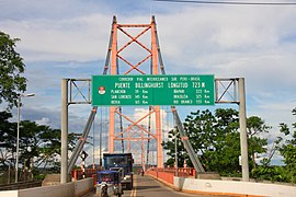
| Bridge over the Rio Madre de Dios. Section of the Interozeanica between the Pacific coast of Peru and the Atlantic coast of Brazil | |
Puerto Maldonado is a city in southeastern Peru and the capital of the Madre de Dios region . It has 77,221 inhabitants (2017). 85,024 people live in the metropolitan area (2017). It is named after the explorer Faustino Maldonado , who led an expedition to the Peruvian Amazon lowlands in 1860 and was lost there in 1861.
The city is the seat of the Apostolic Vicariate Puerto Maldonado .
location
Puerto Maldonado is located in the tropical forest of the Amazon lowlands, 55 km west of the border with Bolivia , at the confluence of the Río Tambopata with the Río Madre de Dios , an Amazon tributary. Puerto Maldonado is on the Transocéanica road , which has linked the Pacific in Peru with the Atlantic in Brazil since 2011. It also connects Cuzco with the Peruvian cities of San Lorenzo , Iberia and Iñapari . The Rio Madre de Dios is crossed by the new Puente Billinghurst bridge.
economy
The original founding of the settlement goes back to the extraction of rubber , but the days of rubber extraction are long gone. Today the city lives primarily from logging, panning for gold , collecting Brazil nuts , building boats and ecotourism , the latter mainly via the airport "Padre Aldamiz" and the new road connection Interoceanica Sur , accessible via Cusco in a good 6 hours is.
The population in the surrounding area has grown significantly due to the new road connection. Several settlements arose on the outskirts through land occupations (span .: invasiones). Gold panning has been given a boost and is now practiced on a large scale. The gold is either washed from the river bed or extracted from sediment deposits. The amalgam process is also used, in which the gold is bound with mercury , which contaminates the environment.
Logging increased again after a temporary decline. In addition to a wood processing company in Puerto Maldonado, others were built in the area.
Changes in EU foreign law have cut off hundreds of nut collectors and the local processing plant from importing into the EU.
Nature reserves
The Manú and Tambopata Candamo national parks are close to the city , as is the Bahuaja Sonene National Park . These nature reserves belong to the few still untouched primary forests of the rainforest belt on earth. The nature reserves are opened up by a number of overnight accommodations for tourists that can only be reached by boat.
climate
The climate is warm and humid all year round, the rainy season lasts from October to April.
| Puerto Maldonado | ||||||||||||||||||||||||||||||||||||||||||||||||
|---|---|---|---|---|---|---|---|---|---|---|---|---|---|---|---|---|---|---|---|---|---|---|---|---|---|---|---|---|---|---|---|---|---|---|---|---|---|---|---|---|---|---|---|---|---|---|---|---|
| Climate diagram | ||||||||||||||||||||||||||||||||||||||||||||||||
| ||||||||||||||||||||||||||||||||||||||||||||||||
|
Average monthly temperatures and rainfall for Puerto Maldonado
Source: wetterkontor.de
|
|||||||||||||||||||||||||||||||||||||||||||||||||||||||||||||||||||||||||||||||||||||||||||||||||||||||||
Web links
Individual evidence
- ↑ Puerto Maldonado - Frendy.de
- ↑ 2017 census
- ↑ Peru: Region Madre de Dios - Provinces & Places . www.citypopulation.de. Retrieved December 19, 2019.
- ↑ Perú: Perfil Sociodemográfico (PDF, 27.4 MB) Instituo Nacional de Estadistica e Informatica (INEI). August 2018. Retrieved December 19, 2019.


