Querbach (Westerbach)
| Querbach | ||
|
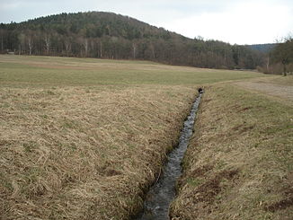
The Querbach in front of Huckelheim |
||
| Data | ||
| Water code | DE : 247722 | |
| location |
Spessart
|
|
| River system | Rhine | |
| Drain over | Westerbach → Kahl → Main → Rhine → North Sea | |
| source | in Arzborn 50 ° 8 '7 " N , 9 ° 15' 45" O |
|
| Source height | 363 m above sea level NHN | |
| confluence | with the Huckelheimer Bach to the Westerbach in Huckelheim Coordinates: 50 ° 7 '39 " N , 9 ° 14' 27" E 50 ° 7 '39 " N , 9 ° 14' 27" E |
|
| Mouth height | 256 m above sea level NHN | |
| Height difference | 107 m | |
| Bottom slope | 54 ‰ | |
| length | 2 km | |
| Catchment area | 2.5 km² | |
The Querbach is the left, northeast and about two kilometers long source brook of the Westerbach in the Lower Franconian district of Aschaffenburg in the Bavarian Spessart .
geography
course
The Querbach rises in Arzborn (sometimes called Atzborn ), a larger spring on the Hohen Querberg (474 m). It is located northeast of Westerngrund , in the Atzborn forest, near the state border with Hesse . The spring water flows from a small opening on the mountain slope.
The Querbach runs in a south-westerly direction to Huckelheim . There it unites with the Huckelheimer Bach to the Westerbach .
Kahl river system
history
Mills
- Middle mill
See also the list of mills in the Kahlgrund .
See also
Web links
Commons : Querbach - collection of images, videos and audio files

