Quimome
| Quimome | ||
|---|---|---|
| Basic data | ||
| Residents (state) | 368 pop. (2012 census) | |
| height | 258 m | |
| Post Code | 07-0501-0101-8002 | |
| Telephone code | (+591) | |
| Coordinates | 17 ° 43 ′ S , 61 ° 10 ′ W | |
|
|
||
| politics | ||
| Department | Santa Cruz | |
| province | Chiquitos Province | |
| climate | ||
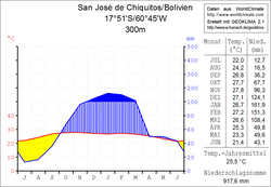
 Climate diagram San José de Chiquitos |
||
Quimome is a town in the Santa Cruz Department in the lowlands of the South American Andean state of Bolivia .
Location in the vicinity
Quimome is the name of a municipality in the district ( Bolivian : Municipio ) of San José de Chiquitos in the province of Chiquitos and is located in the center of the province at an altitude of 258 m east of the departmental capital Santa Cruz , with which it is connected by a railway line. The ridge of the Loma Piedra Negra San Esteban runs south of the village and rises 200 to 300 meters above the plain and continues to the Sierra San José .
geography
South of Quimome, in a tectonic depression, lies the wetland of the Bañados de Izozog , in which the water of the Río Parapetí gathers. In the dry season the basin has no drainage and part of the accumulated moisture evaporates; During the wet season, part of the water flows from the Bañados de Izozog over the Río Quimome , which breaks through the ridge of the Loma Piedra Negra San Esteban near the village of Quimome and feeds the Río Itonomas about 75 kilometers downstream . The climate of the region is subtropical and semi-humid , the plain around Quimome is humid and crossed by numerous streams, so that it has so far hardly been developed agriculturally.
The annual average temperature of the region is 25.5 ° C (see climate diagram San José de Chiquitos), with monthly average temperatures between just under 28 ° C in October and November and below 22 ° C in June. The annual precipitation is 918 mm, the average humidity is 68 percent. The dry season from July to September contrasts with a pronounced wet season from November to March.
Transport network
Quimome is 227 kilometers by road east of Santa Cruz , the capital of the department.
The 1,657-kilometer Ruta 4 highway runs through Quimome and crosses the country from the Chilean to the Brazilian border in a west-east direction . The road leads via Patacamaya , Cochabamba and Villa Tunari to Santa Cruz and from there on via Cotoca and Pailón to Quimome and on via San José de Chiquitos and Roboré to Puerto Suárez .
population
The population of the village has continuously decreased in the past decades:
| year | Residents | source |
|---|---|---|
| 1992 | 478 | census |
| 2001 | 425 | census |
| 2012 | 368 | census |
Individual evidence
- ^ INE - Instituto Nacional de Estadística Bolivia 1992
- ^ INE - Instituto Nacional de Estadística Bolivia 2001
- ↑ INE - Instituto Nacional de Estadística Bolivia 2012 ( Memento of the original from March 4, 2016 in the Internet Archive ) Info: The archive link was inserted automatically and has not yet been checked. Please check the original and archive link according to the instructions and then remove this notice.
Web links
- Topographic map of the La Cantera region 1: 100,000 (JPG; 8.3 MB)
- Relief map of the San José de Chiquitos region 1: 250,000 (PDF; 7.71 MB)
- Todos los caminos conducen a Quimome In: Diario El Día December 2, 2012 ( Spanish ) Retrieved March 2, 2015
- Municipio San José de Chiquitos - General Maps No. 70501
- Municipio San José de Chiquitos - detailed map and population data (PDF; 2.59 MB) ( Spanish )
- Department Santa Cruz - Social data of the municipalities (PDF; 4.99 MB) ( Spanish )
