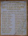
Rétság
| Rétság | |||||
|
|||||
| Basic data | |||||
|---|---|---|---|---|---|
| State : | Hungary | ||||
| Region : | Northern Hungary | ||||
| County : | Nógrád | ||||
| District since 1.1.2013 : | Rétság | ||||
| Coordinates : | 47 ° 56 ' N , 19 ° 8' E | ||||
| Area : | 19.81 km² | ||||
| Residents : | 2,945 (Jan. 1, 2011) | ||||
| Population density : | 149 inhabitants per km² | ||||
| Telephone code : | (+36) 35 | ||||
| Postal code : | 2651 | ||||
| KSH kódja: | 23825 | ||||
| Structure and administration (as of 2016) | |||||
| Community type : | city | ||||
| Mayor : | Ferenc Hegedűs (Fidesz-KDNP) | ||||
| Postal address : | Rákóczi út 20. 2651 Rétság |
||||
| Website : | |||||
| (Source: A Magyar Köztársaság helységnévkönyve 2011. január 1st at Központi statisztikai hivatal ) | |||||


Rétság is a Hungarian city and the seat of the district of the same name in Nógrád County . It is located in the northern low mountain range between Börzsöny and Cserhát .
history
The first written mention was in 1393 as Réthi Saagh . The place already had a church before the Turkish occupation. During this occupation, the population fell sharply: in 1579 there were still 20 taxable houses, in 1633 there were only three. In 1726 a church and a school were built.
Pusztaszánt was first mentioned in writing in 1299 and was an independent municipality in 1460. During the Turkish occupation the place was desolate. A classical castle was built here at the beginning of the 19th century. The population fluctuated around 200. Today the place is part of the city of Rétság.
The city was a garrison town, in 1997 the barracks were closed.
traffic

Rail traffic was stopped on March 4, 2007.
The national road 2 runs through the city and here the national road 22 begins in the direction of Salgótarján .
Attractions
- The lock
- The Roman Catholic Church
- The local museum
- some monuments
gallery

The church
The station

The town hall

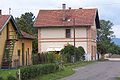
The industrial area

The former barracks
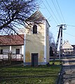
The bell tower of the Protestant church