
Tolmács
| Tolmács | |||||
|
|||||
| Basic data | |||||
|---|---|---|---|---|---|
| State : | Hungary | ||||
| Region : | Northern Hungary | ||||
| County : | Nógrád | ||||
| Small area until December 31, 2012 : | Rétság | ||||
| District since 1.1.2013 : | Rétság | ||||
| Coordinates : | 47 ° 56 ' N , 19 ° 7' E | ||||
| Area : | 12.24 km² | ||||
| Residents : | 691 (Jan. 1, 2011) | ||||
| Population density : | 56 inhabitants per km² | ||||
| Telephone code : | (+36) 35 | ||||
| Postal code : | 2657 | ||||
| KSH kódja: | 06381 | ||||
| Structure and administration (as of 2020) | |||||
| Community type : | local community | ||||
| Mayor : | Ferenc Hajnis (independent) | ||||
| Postal address : | Sport utca 1 2657 Tolmács |
||||
| Website : | |||||
| (Source: A Magyar Köztársaság helységnévkönyve 2011. január 1st at Központi statisztikai hivatal ) | |||||


Tolmács is a Hungarian community in the county Rétság in Nógrád county . It is located about two kilometers west of Rétság .
Parish partnership
Attractions
- Roman Catholic Church Szent Lőrinc , built 1851–1854
- Calvary
- Szentiványi country house ( Szentiványi kúria ), built in the 18th century
- Old wine cellar
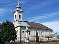
Roman Catholic Church Szent Lőrinc

Old wine cellar

Calvary

Memorial plaque for the victims of the 2nd World War
_(6847._sz%C3%A1m%C3%BA_m%C5%B1eml%C3%A9k).jpg)


traffic
The secondary road No. 12121 runs through Tolmács. The village is located on the Diósjenő - Romhány railway line . However, passenger traffic on this route was discontinued in 2007, so that travelers have to use the train station in Diósjenő located about six kilometers to the west.
Individual evidence
- ↑ Helyi önkormányzati választások 2019 - Tolmács (Nógrád megye). Nemzeti Választási Iroda, October 13, 2019, accessed on July 17, 2020 (Hungarian).
Web links
- Official website ( Hungarian )
- Tolmács near Magyarország helységnévtára (Hungarian)