22-es főút
| 22-es főút in Hungary | |||||||||||||||||||||||||||||||||||||||||||||||||||||||||||||||||||||||||||||||||||||||||||||||||||||||||||||||||||||||||

|
|||||||||||||||||||||||||||||||||||||||||||||||||||||||||||||||||||||||||||||||||||||||||||||||||||||||||||||||||||||||||
| map | |||||||||||||||||||||||||||||||||||||||||||||||||||||||||||||||||||||||||||||||||||||||||||||||||||||||||||||||||||||||||
| Basic data | |||||||||||||||||||||||||||||||||||||||||||||||||||||||||||||||||||||||||||||||||||||||||||||||||||||||||||||||||||||||||
| Operator: | Magyar Közút Nonprofit Zrt. | ||||||||||||||||||||||||||||||||||||||||||||||||||||||||||||||||||||||||||||||||||||||||||||||||||||||||||||||||||||||||
| Start of the street: |
Rétság |
||||||||||||||||||||||||||||||||||||||||||||||||||||||||||||||||||||||||||||||||||||||||||||||||||||||||||||||||||||||||
| End of street: |
Salgótarján |
||||||||||||||||||||||||||||||||||||||||||||||||||||||||||||||||||||||||||||||||||||||||||||||||||||||||||||||||||||||||
| Overall length: | 67 km | ||||||||||||||||||||||||||||||||||||||||||||||||||||||||||||||||||||||||||||||||||||||||||||||||||||||||||||||||||||||||
|
Megyék ( counties ): |
|||||||||||||||||||||||||||||||||||||||||||||||||||||||||||||||||||||||||||||||||||||||||||||||||||||||||||||||||||||||||
|
Course of the road
|
|||||||||||||||||||||||||||||||||||||||||||||||||||||||||||||||||||||||||||||||||||||||||||||||||||||||||||||||||||||||||
22-es főút ( Hungarian for 'main road 22') is a main Hungarian street near the Slovakian border.
course
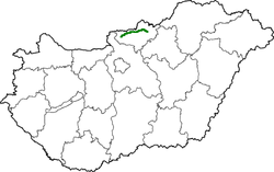
The road begins in Rétság on national road 2 and leads in a north-easterly direction to Ipolyszög . Here it turns east and leads along the Ipoly , which is the border river to Slovakia here, to Szécsény . Further east, in the Zagyvapálfalva district of Salgótarján , the road joins state road 21 .
The total length of the road is 67 kilometers.
history
The road was built in the first years of the 20th century.
See also
Web links
Commons : 22-es főút - collection of images, videos and audio files
- Hungarian Public Road Non-profit AG (Magyar Közút Nonprofit Zrt.) (Hungarian)
- National infrastructure developer, private company (Hungarian, partly English)
Individual evidence
- ↑ Magyarország, autóatlasz 1: 200,000, Honvédelmi Minisztérium Térképészeti Kht., ISBN 978-963-257-087-7 .
