39-es főút
| 39-es főút in Hungary | ||||||||||||||||||||||||||||||||||||||||||||||||||||||||||||||||||||||

|
||||||||||||||||||||||||||||||||||||||||||||||||||||||||||||||||||||||
| map | ||||||||||||||||||||||||||||||||||||||||||||||||||||||||||||||||||||||
| Basic data | ||||||||||||||||||||||||||||||||||||||||||||||||||||||||||||||||||||||
| Operator: | Magyar Közút Nonprofit Zrt. | |||||||||||||||||||||||||||||||||||||||||||||||||||||||||||||||||||||
| Start of the street: |
Encs |
|||||||||||||||||||||||||||||||||||||||||||||||||||||||||||||||||||||
| End of street: |
Mezőzombor |
|||||||||||||||||||||||||||||||||||||||||||||||||||||||||||||||||||||
| Overall length: | 37 km | |||||||||||||||||||||||||||||||||||||||||||||||||||||||||||||||||||||
|
Megyék ( counties ): |
||||||||||||||||||||||||||||||||||||||||||||||||||||||||||||||||||||||
| The street in Mád (photo 2017) | ||||||||||||||||||||||||||||||||||||||||||||||||||||||||||||||||||||||
|
Course of the road
|
||||||||||||||||||||||||||||||||||||||||||||||||||||||||||||||||||||||
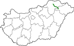
39-es főút ( Hungarian for 'main street 39') is a Hungarian main street . It begins in Encs at 3-as főút and runs in a generally south-easterly direction via Abaújszántó to Mád and another 2 km to Mezőzombor to 37-es főút , where it ends. The total length is 37 kilometers.
Traffic volume
Average daily traffic on the main road
| section | DTV |
|---|---|
| Encs (0.00 km - 1.29 km) | 5,873 |
| Abaújszántó (11.81 km - 17.47 km) | 5,357 |
| Mád (20.28 km - 28.88 km) | 4,283 |
See also
Web links
Commons : 39-es főút - collection of images, videos and audio files
- Hungarian Public Road Non-profit AG (Magyar Közút Nonprofit Zrt.) (Hungarian)
- National infrastructure developer, private company (Hungarian, partly English)
Individual evidence
- ↑ Magyarország, autóatlasz 1: 200,000, Honvédelmi Minisztérium Térképészeti Kht., ISBN 978-963-257-087-7 .
- ↑ Forgalomszámlálás (Report of the Federal Highway Research Institute.) .

