Autóút M0
| M0-s autópálya in Hungary | ||||||||||||||||||||||||||||||||||||||||||||||||||||||||||||||||||||||||||||||||||||||||||||||||||||||||||||||||||||||||||||||||||||||||||||||||||||||||||||||||

|
||||||||||||||||||||||||||||||||||||||||||||||||||||||||||||||||||||||||||||||||||||||||||||||||||||||||||||||||||||||||||||||||||||||||||||||||||||||||||||||||
| |
||||||||||||||||||||||||||||||||||||||||||||||||||||||||||||||||||||||||||||||||||||||||||||||||||||||||||||||||||||||||||||||||||||||||||||||||||||||||||||||||
| map | ||||||||||||||||||||||||||||||||||||||||||||||||||||||||||||||||||||||||||||||||||||||||||||||||||||||||||||||||||||||||||||||||||||||||||||||||||||||||||||||||
| Basic data | ||||||||||||||||||||||||||||||||||||||||||||||||||||||||||||||||||||||||||||||||||||||||||||||||||||||||||||||||||||||||||||||||||||||||||||||||||||||||||||||||
| Operator: | ||||||||||||||||||||||||||||||||||||||||||||||||||||||||||||||||||||||||||||||||||||||||||||||||||||||||||||||||||||||||||||||||||||||||||||||||||||||||||||||||
| Overall length: | 103 km | |||||||||||||||||||||||||||||||||||||||||||||||||||||||||||||||||||||||||||||||||||||||||||||||||||||||||||||||||||||||||||||||||||||||||||||||||||||||||||||||
| of which in operation: | 78 km | |||||||||||||||||||||||||||||||||||||||||||||||||||||||||||||||||||||||||||||||||||||||||||||||||||||||||||||||||||||||||||||||||||||||||||||||||||||||||||||||
| of which in planning: | 25 km | |||||||||||||||||||||||||||||||||||||||||||||||||||||||||||||||||||||||||||||||||||||||||||||||||||||||||||||||||||||||||||||||||||||||||||||||||||||||||||||||
|
Megyék ( counties ): |
||||||||||||||||||||||||||||||||||||||||||||||||||||||||||||||||||||||||||||||||||||||||||||||||||||||||||||||||||||||||||||||||||||||||||||||||||||||||||||||||
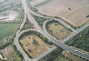
| Aerial view of the M0 | ||||||||||||||||||||||||||||||||||||||||||||||||||||||||||||||||||||||||||||||||||||||||||||||||||||||||||||||||||||||||||||||||||||||||||||||||||||||||||||||||
|
Course of the road
|
||||||||||||||||||||||||||||||||||||||||||||||||||||||||||||||||||||||||||||||||||||||||||||||||||||||||||||||||||||||||||||||||||||||||||||||||||||||||||||||||
Autóút M0 ( Hungarian for, expressway M0 ') is an expressway in Hungary and beltway of Budapest . In the west of Budapest it connects the motorways M1 (from Vienna ) and the M7 (towards Balaton ) with the M5 (towards the south). The M6 connection (towards Dunaújváros ) was completed in September 2008. The further expansion of the M0 towards the east with a connection to the M3 towards Debrecen and Miskolc , M2 towards Vác , and road 11 towards Szentendre through the new Megyeri Bridge was implemented in September 2008. As a result, the connection between Eastern Hungary and Budapest Airport has been significantly improved.
The long-term goal is a motorway ring that completely surrounds Budapest. The planned final length is 103 to 105 kilometers, of which 78 kilometers are currently in operation.
Large parts of the M0 (e.g. in the east of Budapest) are declared as an expressway. Therefore, there is a speed limit of 110 km / h instead of the 130 km / h otherwise usual on motorways in Hungary.
With 65,280 vehicles per day, the M0 has the second highest traffic volume in Hungary - after the M3 with 68,997 vehicles / day. The M0 is thus one of the most important long-distance roads in Hungary.
Sections (Sectors)
The M0 can be divided into 4 main sectors:
- Southern sector: between the M1 motorway and the M5 motorway
- Eastern sector: between the M5 and M3 motorways
- Northern sector: between the M3 and M10 motorways
- Western sector: between the M10 motorway and the M1 motorway
The mileage is based on the M1 and runs counter-clockwise
history
The idea of a motorway around the capital came up as early as 1942, but implementation had to wait several decades. In the 1960s it was planned to unite the radial motorways on a high-altitude motorway (based on the idea of the Paris Périphérique ) in the urban area of Budapest. In 1974 the Hungarian National Motorway Development Plan (OMFB) was completed. In this context, detailed planning studies for the construction of a motorway bypass around the capital were proposed. This ring should fulfill the task of collecting and distributing traffic on the border of the built-up areas. At this time, the plans for the previous sections, namely the northern, southern, eastern and western sectors, arose. In 1982 it was decided to build a section between M1 and M5. The document of the National Development Plan for the Hungarian Road Network of 1985 confirmed this route.
As the inner areas of Budapest became more and more frequented, the M0 ring had to have four main functions: The ring connects and organizes the radial highways, relieves densely populated areas of the capital from through traffic, traffic recording, plays a distributive role and helps to keep the traffic of the Capital to organize the suburbs and commuter cities. Work began in 1987, and at the end of 1990 the first major section connecting Main Road 6 to the M5 motorway was completed. The traffic-related importance of the new route was mainly determined by the Danube bridges south of Csepel . In 1994, the southern sector was completed along its entire length and the 29.5 kilometer section now crosses three motorways (M1, M6, M7, M5). In the first step, the originally designed two-lane plan was shortened to save money. As a result of the more modest technical solution, the road was often referred to as the "sanctuary of death" due to the frequent fatal accidents. At the time of construction, the plan was to take the eastern section closer to Liszt Ferenc Airport (then Ferihegy Airport). For this reason, the M51 motorway (which used to be the eastern end of the southern section) was linked further north with the M5 motorway.
Concrete elements were placed between the directional lanes in order to avoid head-on collisions in the busy southern sector. In 2005, the section between the M5 and M4 motorways was completed, and on September 16, 2008 it reached the M3 motorway and main road No. 1, completing the eastern and northern sectors. In 2008 the section between the M4 motorway and the M3 motorway, as well as that between the main road 2 and the main road 11. The latter includes the 1,862 m long Megyeri Bridge . On July 22, 2012, the expansion of the route between the motorway triangle with the M6 and the M7 was opened. On June 30, 2013 the 11 km long extension of the route between the motorway triangle with the M6 and the main road 51 was opened. On April 16, 2010, work began on the stretch between Törökbálint and Biatorbágy . This goal was to bring the motorway to a higher level of safety so that this section became a 6-lane motorway, which was completed by July 22, 2015. During this time, on August 31, 2013, the 6.3 km long section was transferred to the new M51 motorway (between the main road 51 and the M5 motorway).
Chargeable routes on the M0
Since January 1, 2015, parts of the M0 have been subject to tolls for car traffic. The toll routes include the sections in southwest Budapest from the cross with the M5 (30 km) to the cross with the M4 (42 km) and from the cross with the M3 (69 km) to the Újpest exit (75 km).
The introduced toll collection actually contradicts the goal of keeping traffic out of the inner cities.
Web links
- National Motorway AG Hungary (Hungarian)
- Aerial photos of the M0
- Autobahn portal (German)
Individual evidence
- ↑ a b Statistics: Average daily traffic - 2012. ( Memento from October 5, 2013 in the Internet Archive ) (Hungarian; PDF; 5.1 MB). P. 28.
- ^ National toll collection by a closed service company. In: maut-tarife.hu. Retrieved March 24, 2016 .
- ↑ Revenge for dead internet tax: Budapest motorway ring becomes toll. In: www.pesterlloyd.net. Retrieved March 24, 2016 .


