
Golop
| Golop | |||||
|
|||||
| Basic data | |||||
|---|---|---|---|---|---|
| State : | Hungary | ||||
| Region : | Northern Hungary | ||||
| County : | Borsod-Abaúj-Zemplén | ||||
| Small area until December 31, 2012 : | Szerencs | ||||
| District since 1.1.2013 : | Szerencs | ||||
| Coordinates : | 48 ° 14 ' N , 21 ° 11' E | ||||
| Height : | 132 m | ||||
| Area : | 9.43 km² | ||||
| Residents : | 555 (Jan. 1, 2011) | ||||
| Population density : | 59 inhabitants per km² | ||||
| Telephone code : | (+36) 47 | ||||
| Postal code : | 3906 | ||||
| KSH kódja: | 13134 | ||||
| Structure and administration (as of 2020) | |||||
| Community type : | local community | ||||
| Mayoress : | Helga Angelovics (independent) | ||||
| Postal address : | Fő utca 1 3906 Golop |
||||
| Website : | |||||
| (Source: A Magyar Köztársaság helységnévkönyve 2011. január 1st at Központi statisztikai hivatal ) | |||||


Golop is a Hungarian community in district Szerencs in Borsod-Abaúj-Zemplén .
Geographical location
Golop is located in northern Hungary , 45 kilometers northeast of the Miskolc county seat . Neighboring communities within four kilometers are Monok and Tállya . The nearest town, Abaújszántó , is five kilometers north of Golop.
Attractions
- Reformed church, built in the 18th century
- Szűz Mária Neve Roman Catholic Church , built in the 19th century
- Vay locks ( Vay-kastélyok )
- Collection of coats of arms ( Címertár ) in the castle
traffic
The road No. 3711 runs through Golop, to the east of the town the main road No. 39. The nearest train station is in Tállya.
photos

Aerial photograph of the Vay castles (2004)
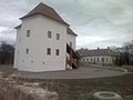
Vay Castle (2012)

Vay Castle (2016)

Vay Castle (2016)
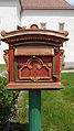
Mailbox at the castle (2016)


_of_Golop,_Hungary_2.jpg)
_of_Golop,_Hungary_1.jpg)
_of_Golop,_Hungary_10.jpg)
Individual evidence
- ^ Borsod-Abaúj-Zemplén megye polgármestereinek névsora. BOON, October 14, 2019, accessed February 29, 2020 (Hungarian).
Web links
- Official website ( Hungarian )
- A golopi református templom (Hungarian)
- Aerial views of Golop