
Csitár
| Csitár | |||||
|
|||||
| Basic data | |||||
|---|---|---|---|---|---|
| State : | Hungary | ||||
| Region : | Northern Hungary | ||||
| County : | Nógrád | ||||
| Small area until December 31, 2012 : | Balassagyarmat | ||||
| District since 1.1.2013 : | Balassagyarmat | ||||
| Coordinates : | 48 ° 3 ' N , 19 ° 26' E | ||||
| Area : | 16.85 km² | ||||
| Residents : | 385 (Jan. 1, 2011) | ||||
| Population density : | 23 inhabitants per km² | ||||
| Telephone code : | (+36) 35 | ||||
| Postal code : | 2673 | ||||
| KSH kódja: | 05050 | ||||
| Structure and administration (status: 2018) | |||||
| Community type : | local community | ||||
| Structure : | Csitár, Nógrádgárdony | ||||
| Mayor : | István Komjáti (independent) | ||||
| Postal address : | Petőfi Sándor u. 40-42 2673 Csitár |
||||
| Website : | |||||
| (Source: A Magyar Köztársaság helységnévkönyve 2011. január 1st at Központi statisztikai hivatal ) | |||||


Csitár is a Hungarian community in the county Balassagyarmat in Nógrád county . The district of Nógrádgárdony in the southwest belongs to the municipality .
Geographical location
Csitár is ten kilometers east of the city of Balassagyarmat , on the small river Csitári-patak . Neighboring communities are Iliny and Őrhalom.
Attractions
- Roman Catholic Church Szent Kereszt felmagasztalása , built in 1747 (Baroque)
- Sandstone crosses ( homokkő keresztek ), erected around 1800
- Mailáth Castle (Mailáth kastély), built in 1895 in the district of Nógrádgárdony
traffic
Road No. 2119 runs through Csitár. The nearest train station is three kilometers northwest in Őrhalom.
photos
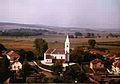
Roman Catholic Church of Szent Kereszt felmagasztalása

Interior of the church


literature
- József Zólyomi: Csitár Története. Csitár 1999.
Web links
- Official website ( Hungarian )
- Csitár at tourinform (Hungarian)
- Majláth-kastély at kastelyok.com (Hungarian)