Salgótarján County
| circle Salgótarjáni járás
Salgótarján |
|
|---|---|
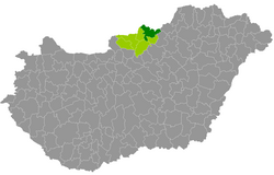
 Location of the district in Hungary |
|
| Basic data | |
| Country | Hungary |
| County | Nógrád |
| Seat | Salgótarján |
| surface | 525.2 km² |
| Residents | 61,625 (January 1, 2016) |
| density | 117 inhabitants per km² |
The Salgótarján District (Hungarian Salgótarjáni járás ) is a district in the northeast of the northern Hungarian Nógrád County . It borders on the Szécsény district to the west and the Pásztó and Bátonyterenye districts to the south . In the east, which forms Heves the border and in the north-east in a small piece (~ 7 km), the Borsod-Abaúj-Zemplén . In the north, 11 municipalities border Slovakia .
history
During the Hungarian administrative reform in early 2013, the district emerged with 23 of the 24 municipalities from its predecessor, the small area of the same name (Hungarian Salgótarjáni kistérség ). The municipality of Szalmatercs was transferred to the western neighboring district of Szécsény . In return, the Salgótarján district received 6 communities from the small area of Bátonyterenye, a little further south . This resulted in an area increase for the followers of 10.7% (area) and 2.9% (population).
Community overview
The Salgótarján district has an average community size of 2,125 inhabitants on an area of 18.11 square kilometers. Without the district town these values decrease to 944 inhabitants. and 15.26 km², respectively. The population density of the most populous district is the highest in the county and is about one and a half times the county value. The administrative center is located in the only town, Salgótarján , in the center of the district. Salgotarjan as the administrative center of Nógrád county is legally equivalent to a county (Hungarian Megyei jogú város ).
| local community | status | Origin small area |
population | Area (km²) | Population density (inh / km²) |
||
|---|---|---|---|---|---|---|---|
| October 01, 2011 | 01/01/2013 | 01/01/2016 | |||||
| Bárna | local community | Salgótarján | 1,090 | 1,081 | 1,032 | 15.39 | 67.1 |
| Cered * | local community | Salgótarján | 1,127 | 1,122 | 1,093 | 38.58 | 28.3 |
| Egyházasgerge * | local community | Salgótarján | 765 | 741 | 722 | 15.37 | 47.0 |
| Etes | local community | Salgótarján | 1,427 | 1,429 | 1,349 | 15.80 | 85.4 |
| Ipolytarnóc * | local community | Salgótarján | 445 | 452 | 460 | 13.66 | 33.7 |
| Karancsalja | local community | Salgótarján | 1,554 | 1,557 | 1,512 | 12.54 | 120.6 |
| Karancsberény * | local community | Salgótarján | 905 | 884 | 846 | 23.14 | 36.6 |
| Karancskeszi * | local community | Salgótarján | 1,883 | 1,905 | 1,858 | 31.68 | 58.6 |
| Karancslapujtő * | local community | Salgótarján | 2,594 | 2,651 | 2,543 | 19.35 | 131.4 |
| Karancsság | local community | Salgótarján | 1,202 | 1,242 | 1,266 | 21.39 | 59.2 |
| Kazar | local community | Salgótarján | 1,864 | 1,870 | 1,785 | 30.39 | 58.7 |
| Kisbárkány | local community | Bátonyterenye | 213 | 194 | 145 | 8.03 | 18.1 |
| Kishartyán | local community | Salgótarján | 570 | 536 | 527 | 8.95 | 58.9 |
| Litke * | local community | Salgótarján | 870 | 885 | 857 | 18.16 | 47.2 |
| Lucfalva | local community | Bátonyterenye | 633 | 631 | 595 | 14.10 | 42.2 |
| Márkháza | local community | Bátonyterenye | 244 | 252 | 274 | 6.31 | 43.4 |
| Mátraszele | local community | Salgótarján | 979 | 984 | 913 | 16.97 | 53.8 |
| Mihálygerge * | local community | Salgótarján | 605 | 595 | 565 | 11.06 | 51.1 |
| Nagybárkány | local community | Bátonyterenye | 687 | 673 | 695 | 8.84 | 78.6 |
| Nagykeresztúr | local community | Bátonyterenye | 259 | 247 | 251 | 8.20 | 30.6 |
| Rákóczibánya | local community | Salgótarján | 658 | 677 | 681 | 4.57 | 149.0 |
| Ságújfalu | local community | Salgótarján | 1,053 | 1,059 | 1,017 | 12.03 | 84.5 |
| Salgótarján * | city | Salgótarján | 37,262 | 37.199 | 35,188 | 97.97 | 359.2 |
| Sámsonháza | local community | Bátonyterenye | 259 | 270 | 254 | 12.71 | 20.0 |
| Somoskőújfalu * | local community | Salgótarján | 2,353 | 2,280 | 2.165 | 5.19 | 417.1 |
| Sóshartyán | local community | Salgótarján | 933 | 955 | 999 | 12.14 | 82.3 |
| Szilaspogony | local community | Salgótarján | 300 | 296 | 295 | 14.40 | 20.5 |
| Vizslás | local community | Salgótarján | 1,377 | 1,347 | 1.317 | 10.12 | 130.1 |
| Zabar * | local community | Salgótarján | 490 | 490 | 421 | 18.17 | 23.2 |
| Salgótarján County | 64,601 | 64.504 | 61,625 | 525.21 | 117.3 | ||
* Border municipality to Slovakia
swell
PDF and XLS files: 2011
Census :
2013:; 2016:
Individual evidence
- ↑ KSH: 2011. Évi Népszámlálás. In: 3. Területi adatok. KSH, accessed on December 26, 2016 (Hungarian, also via: http://www.terezvaros.hu/testuleti/nepsz2011-3/pdf/nepsz2011_03_12.pdf ).
- ↑ KSH: Regional data - Nógrád county. KSH, accessed on December 26, 2016 (English, 4th Data on Localities).
- ↑ KSH: Gazetteer of Hungary, 1st January, 2013. KSH, accessed on March 29, 2017 (Hungarian / English).
- ↑ KSH: Gazetteer of Hungary, 1st January, 2016. KSH, accessed on March 29, 2017 (Hungarian / English).