
Sámsonháza
| Sámsonháza | |||||
|
|||||
| Basic data | |||||
|---|---|---|---|---|---|
| State : | Hungary | ||||
| Region : | Northern Hungary | ||||
| County : | Nógrád | ||||
| Small area until December 31, 2012 : | Bátonyterenye | ||||
| District since 1.1.2013 : | Salgótarján | ||||
| Coordinates : | 47 ° 59 ' N , 19 ° 43' E | ||||
| Area : | 12.71 km² | ||||
| Residents : | 272 (Jan. 1, 2011) | ||||
| Population density : | 21 inhabitants per km² | ||||
| Telephone code : | (+36) 32 | ||||
| Postal code : | 3074 | ||||
| KSH kódja: | 24572 | ||||
| Structure and administration (as of 2020) | |||||
| Community type : | local community | ||||
| Mayoress : | Gyöngyi Bajnokné Képes (independent) | ||||
| Postal address : | Rákóczi Ferenc u. 47 3074 Sámsonháza |
||||
| Website : | |||||
| (Source: A Magyar Köztársaság helységnévkönyve 2011. január 1st at Központi statisztikai hivatal ) | |||||


Sámsonháza ( Slovak Šámšonház ) is a Hungarian community in the county Salgótarján in Nógrád county .
Geographical location
Sámsonháza is located about seven kilometers north of the town of Pásztó on the Kis-Zagyva River . Neighboring communities are Nagybárkány, Márkháza, Tar and Mátraverebély .
Sons and daughters of the church
- Lajos Haan (1818–1891), clergyman and historiographer
- Júlia Kukely (1953-2017), opera singer
Attractions
- Evangelical Church, built around 1870
- Geological nature trail ( Geológiai tanösvény )
- Heroes' monument ( Hősi emlékmű ), in memory of the victims of the Hungarian Revolution of 1848/1849 and of the First and Second World Wars
- Remains of the Fejérkő vára castle ruins , north of the village
- Slovak Local History Museum ( Szlovák tájház )
traffic
The side road No. 21135 runs through Sámsonháza. The nearest train station is four kilometers south in Tar.
photos
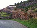
Geological nature trail

Heroes Monument

View of the castle ruins


Web links
- Official website ( Hungarian )
- Sámsonházi szlovákság (Hungarian)