
Mátraverebély
| Mátraverebély | |||||
|
|||||
| Basic data | |||||
|---|---|---|---|---|---|
| State : | Hungary | ||||
| Region : | Northern Hungary | ||||
| County : | Nógrád | ||||
| Small area until December 31, 2012 : | Bátonyterenye | ||||
| District since 1.1.2013 : | Bátonyterenye | ||||
| Coordinates : | 47 ° 58 ' N , 19 ° 47' E | ||||
| Area : | 18.4 km² | ||||
| Residents : | 2,068 (Jan 1, 2011) | ||||
| Population density : | 112 inhabitants per km² | ||||
| Telephone code : | (+36) 32 | ||||
| Postal code : | 3077 | ||||
| KSH kódja: | 30100 | ||||
| Structure and administration (status: 2018) | |||||
| Community type : | local community | ||||
| Structure : | Mátraverebély, Kányástelep, Kányáspuszta, Szentkút, Csengerháza | ||||
| Mayor : | Attila Nagy (independent) | ||||
| Postal address : | Vasút et al. 82 3077 Mátraverebély |
||||
| Website : | |||||
| (Source: A Magyar Köztársaság helységnévkönyve 2011. január 1st at Központi statisztikai hivatal ) | |||||


Mátraverebély is a Hungarian community in the county Bátonyterenye in Nógrád county . The districts Kányástelep , Kányáspuszta , Szentkút and Csengerháza belong to the municipality . The district of Szentkút , whose name means Holy Well , has a special meaning as a place of pilgrimage . Pilgrims from home and abroad have been visiting the place for eight centuries.
Geographical location
Mátraverebély is located between the towns of Bátonyterenye and Pásztó on the Zagyva River . Neighboring communities are Sámsonháza, Nagybátony and Tar.
Parish partnership
-
 Vereb , Hungary (since 2007)
Attractions
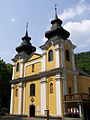
- Nagyboldogasszony Roman Catholic Church
In the district of Szentkút
- Well Szent Kút with statue
- Hermit Caves ( Remetebarlangok )
- Open-air exhibition area ( Szabadtéri miséző ) with mosaics
- Calvaries and Calvary Chapel ( Kálvária és kálvária-kápolna )
- Bazilika Nagyboldogasszony
- Szent László Spring ( Szent László-forrás )
traffic
Main road 21 runs through Mátraverebély . The community is connected to the railway line from Hatvan to Somoskőújfalu .
photos

Roman Catholic Nagyboldogasszony Church
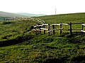
Kányáspuszta
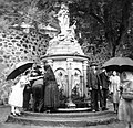
Fountain Szent Kút (1937)

Hermit caves
Bazilika Nagyboldogasszony

Mosaic at the open-air exhibition center
_(6720._sz%C3%A1m%C3%BA_m%C5%B1eml%C3%A9k)_5.jpg)


_3.jpg)
_(6722._sz%C3%A1m%C3%BA_m%C5%B1eml%C3%A9k)_3.jpg)
