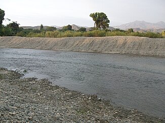
Río Huarmey
|
Río Huarmey Río Aija |
||
| Data | ||
| location |
|
|
| River system | Río Huarmey | |
| Headwaters |
Cordillera Negra 9 ° 37 ′ 43 ″ S , 77 ° 37 ′ 1 ″ W. |
|
| Source height | approx. 4500 m | |
| muzzle |
Pacific Ocean Coordinates: 10 ° 5 ′ 28 ″ S , 78 ° 10 ′ 0 ″ W 10 ° 5 ′ 28 ″ S , 78 ° 10 ′ 0 ″ W |
|
| Mouth height | 0 m | |
| Height difference | approx. 4500 m | |
| Bottom slope | approx. 45 ‰ | |
| length | approx. 100 km | |
| Catchment area | approx. 2100 km² | |
| Left tributaries | Río Malvas | |
| Small towns | Huarmey | |
| Communities | La Merced , Aija | |
The Río Huarmey , above the confluence of the Río Malvas also Río Aija , is an approx. 100 km long tributary of the Pacific Ocean in central western Peru in the provinces of Aija and Huarmey of the administrative region Ancash .
River course
The Río Huarmey rises in the Cordillera Negra , a mountain range of the Peruvian Western Cordillera , in the province of Aija at an altitude of about 4500 m . On the upper 65 kilometers, the Río Huarmey flows mainly in a south-westerly direction through the mountains. At river kilometer 85 the river passes the La Merced district administration center . At river kilometer 80 Aija is about one kilometer east of the river. The Río Malvas meets the Río Huarmey from the left 42 kilometers above the mouth . This turns west for the lower 35 kilometers. 3 km above the mouth, the river passes the town of Huarmey on the right bank of the river . The Panamericana highway crosses the river there. This eventually reaches a lagoon on the Pacific coast. Irrigated agriculture is practiced on the lower reaches.
Catchment area and hydrology
The Río Huarmey drains an area of about 2100 km². The catchment area borders on that of the Río Culebras in the north, that of the Río Casma in the northeast, that of the Río Santa in the east and that of the Río Fortaleza in the southeast . The Río Huarmey carries very little water from July to September.
