Huarmey Province
| Huarmey Province | |||
|---|---|---|---|
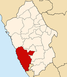
 Location of the province in the Ancash region |
|||
| Symbols | |||
|
|||
| Basic data | |||
| Country | Peru | ||
| region | Ancash | ||
| Seat | Huarmey | ||
| surface | 3,908.4 km² | ||
| Residents | 30,560 (2017) | ||
| density | 7.8 inhabitants per km² | ||
| founding | December 20, 1984 | ||
| ISO 3166-2 | PE-ANC | ||
| Website | munihuarmey.gob.pe (Spanish) | ||
| politics | |||
| Alkalis | Elmer Alfonso Dueñas Espíritu (2019-2022) |
||
| Balneario de Tuquillo | |||
Coordinates: 10 ° 8 ′ S , 77 ° 57 ′ W
The Huarmey Province is one of the 20 provinces that make up the Ancash administrative region in Peru . In 2017, 30,560 people lived in the 3,908.4 km² area, which corresponds to a population density of 7.8 inhabitants per km². The administrative seat is in Huarmey .
Geographical location
The province of Huarmey is located 230 km north-northwest of the state capital Lima . The province stretches for 95 km along the Pacific coast . It extends up to 70 km inland. In the east of the province rise the mountains of the Cordillera Negra , a lower mountain range of the Peruvian Western Cordillera . The rivers Río Culebras and Río Huarmey flow into the sea in the province. In the south the province extends into the river valley of the Río Fortaleza . In the north, the province of Huarmey is bordered by the province of Casma , in the east by the provinces of Huaraz , Aija , Recuay and Bolognesi . In the south is the province of Barranca .
structure
The Huarmey province consists of 5 districts ( distritos ). The Huarmey district is the seat of the provincial government.
| District | Administrative headquarters |
|---|---|
| Cochapeti | Cochapeti |
| Culebras | La Caleta Culebras |
| Huarmey | Huarmey |
| Huayán | Huayán |
| Malvas | Malvas |


