Antonio Raymondi Province
| Antonio Raymondi Province | |
|---|---|
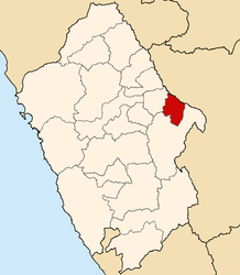
 Location of the province in the Ancash region |
|
| Basic data | |
| Country | Peru |
| region | Ancash |
| Seat | Llamellín |
| surface | 561.6 km² |
| Residents | 13,650 (2017) |
| density | 24 inhabitants per km² |
| founding | October 26, 1964 |
| ISO 3166-2 | PE-ANC |
| politics | |
| Alcalde Provincial | Félix Sandoval Díaz (2019-2022) |
| View of Llamellín | |
Coordinates: 9 ° 7 ′ S , 77 ° 4 ′ W
The Antonio Raymondi Province (alternative spelling: Antonio Raimondi Province ) is one of the 20 provinces that make up the Ancash region in Peru . In 2017, 13,650 people lived in the 561.61 km² area. In 1993 the population was 18,912, in 2007 it was 17,059. The administrative seat of the province is Llamellín . The province was named after the Italian-Peruvian geographer Antonio Raimondi .
Geographical location
The province lies on the eastern slope of the Peruvian Western Cordillera . The main ridge of the glaciated Cordillera Blanca rises 45 km to the west . In the northeast the upper reaches of the Río Marañón and in the east its tributary Río Puchca form the provincial border. The north-western part of the province is traversed by the Quebrada Pañoragra , another tributary of the Río Marañón. The lowest point of the province is at an altitude of about 2000 m . The highest mountains reach heights of over 4600 m .
The province of Antonio Raymondi borders the Huánuco region to the northeast, the Carlos Fermín Fitzcarrald province to the west and the Huari province to the south .
Administrative division
The Antonio Raymondi Province consists of the following six districts. The Llamellín district is the seat of the provincial administration.
| District | Administrative headquarters |
|---|---|
| Aczo | Aczo |
| Chaccho | Chaccho |
| Chingas | Chingas |
| Llamellín | Llamellín |
| Mirgas | Mirgas |
| San Juan de Rontoy | San Juan de Rontoy |
Web links
- Peru: Region Ancash (provinces and districts) at www.citypopulation.de
