Casma Province
| Casma Province | |||
|---|---|---|---|
 Location of the province in the Ancash region |
|||
| Symbols | |||
|
|||
| Basic data | |||
| Country | Peru | ||
| region | Ancash | ||
| Seat | Casma | ||
| surface | 2,262.9 km² | ||
| Residents | 50,989 (2017) | ||
| density | 23 inhabitants per km² | ||
| founding | July 25, 1955 | ||
| ISO 3166-2 | PE-ANC | ||
| politics | |||
| Alcalde Provincial | Luis Wilmer Alarcón Llana (2019-2022) |
||
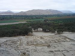
| Cerro Sechín archaeological site | |||
Coordinates: 9 ° 28 ′ S , 78 ° 18 ′ W
The province of Casma is one of the 20 provinces that make up the Ancash region in Peru . The province was founded on July 25, 1955. In 2017, 50,989 people lived in the 2262.86 km² area. In 1993 the population was 35,380, in 2007 it was 42,368. The administrative seat of the province is the town of the same name Casma . There are several archaeological sites in the province.
Geographical location
The province of Casma is located on the Pacific coast 315 km north-northwest of the state capital Lima . It is bordered to the south by the province of Huarmey , to the east by the provinces of Huaraz and Yungay and to the north by the province of Santa . The provincial area is traversed by the Río Casma and its right tributaries Río Yaután and Río Sechín . Irrigated agriculture is practiced along these rivers.
Districts of the Province
The province of Casma consists of four districts. The Casma district is the seat of the provincial administration.
| District | Administrative headquarters |
|---|---|
| Casma | Casma |
| Buenavista Alta | Buenavista Alta |
| Comandante Noel | Puerto Casma |
| Yautan | Yautan |
Web links
- Peru: Region Ancash (provinces and districts) at www.citypopulation.de


