Yungay Province
| Yungay Province | |||
|---|---|---|---|
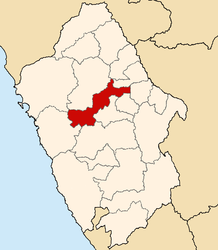
 Location of the province in the Ancash region |
|||
| Symbols | |||
|
|||
| Basic data | |||
| Country | Peru | ||
| region | Ancash | ||
| Seat | Yungay | ||
| surface | 1,361.5 km² | ||
| Residents | 50,841 (2017) | ||
| density | 37 inhabitants per km² | ||
| founding | October 28, 1904 | ||
| ISO 3166-2 | PE-ANC | ||
| Website | yungayperu.com.pe (Spanish) | ||
| politics | |||
| Alcalde Provincial | Fernando Ciro Casio Consolación (2019-2022) |
||
| View from the north of the two peaks of Nevado Huascarán | |||
Coordinates: 9 ° 10 ′ S , 77 ° 43 ′ W
The Yungay Province is one of the 20 provinces that make up the Ancash administrative region in Peru . In 2017, 50,841 people lived in the 1361.48 km² area, which corresponds to a population density of 37 inhabitants per km². The administrative seat is in Yungay .
Geographical location
The province of Yungay extends over a nearly 20 km long section of the high valley Callejón de Huaylas between the Cordillera Negra in the west and the Cordillera Blanca in the east. The longitudinal extension in WSW-ONE direction is 86 km. In the east of the province rises the highest mountain in Peru, the 6768 m high Nevado Huascarán . In the north, the province of Yungay borders on the province of Huaylas , in the south on the provinces of Carhuaz and Huaraz , in the west on the province of Casma and in the east on the provinces of Asunción , Carlos Fermín Fitzcarrald , Mariscal Luzuriaga and Pomabamba .
structure
The Yungay Province consists of eight districts ( distritos ). The district of Yungay is the seat of the provincial administration.
| District | Administrative headquarters |
|---|---|
| Cascapara | Cascapara |
| Mancos | Mancos |
| Matacoto | Matacoto |
| Quillo | Quillo |
| Ranrahirca | Ranrahirca |
| Shupluy | Shupluy |
| Yanama | Yanama |
| Yungay | Yungay |


