Mancos District
| Mancos District | |
|---|---|
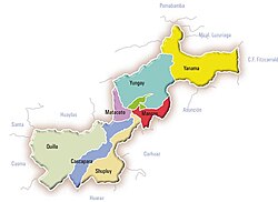
 The Mancos District (marked in red) is located in the southeast of the Yungay Province |
|
| Basic data | |
| Country | Peru |
| region | Ancash |
| province | Yungay |
| Seat | Mancos |
| surface | 62.9 km² |
| Residents | 6863 (2017) |
| density | 109 inhabitants per km² |
| founding | January 2, 1857 |
| ISO 3166-2 | PE-ANC |
| politics | |
| Alcalde District | Walter Emigdio Gómez Bazán (2019-2022) |
Coordinates: 9 ° 11 ′ 26 " S , 77 ° 42 ′ 45" W.
The Mancos district is located in the Yungay Province in the Ancash region of western Peru . The district founded on January 2, 1857 has an area of 62.9 km². The 2017 census counted 6,863 inhabitants. In 1993 the population was 7712, in 2007 it was 7180. The administrative seat is the small town of Mancos with 1525 inhabitants located at an altitude of 2507 m (as of 2017). Mancos is 13 km southeast of the provincial capital Yungay .
Geographical location
The Mancos District is located in the southeast of the Yungay Province. It lies on the western flank of the Cordillera Blanca and extends in the west to the east bank of the Río Santa, which flows to the northwest .
The Mancos district is bordered to the west by the Ataquero districts ( Carhuaz Province ), Shupluy and Matacoto , to the north by the Ranrahirca and Yungay districts , to the east and south-east by the Shilla district and to the south by the Amashca and Tinco districts (the three last mentioned districts belong to the province of Carhuaz).
Localities
In addition to the main town, the district also has the following larger towns (centros poblados):
- Huashcao
- Huaypan (353 inhabitants)
- Tingua (764 inhabitants)
- Utupampa (173 inhabitants)
- Yanamito (238 inhabitants)
Web links
- Peru: Region Ancash (provinces and districts) at www.citypopulation.de
- INEI Perú