Shilla District
| Shilla District | |
|---|---|
 The Shilla District is located in the far northeast of the Carhuaz Province (marked in red) |
|
| Basic data | |
| Country | Peru |
| region | Ancash |
| province | Carhuaz |
| Seat | Shilla |
| surface | 130.2 km² |
| Residents | 2789 (2017) |
| density | 21 inhabitants per km² |
| founding | December 14, 1934 |
| ISO 3166-2 | PE-ANC |
| Website | munishilla.gob.pe (Spanish) |
| politics | |
| Alcalde District | Vidal Orlando Collpa Leyva (2019-2022) |
| Political party | Movimiento Acción Nacionalista Peruano |
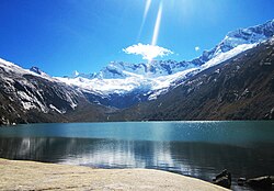
| Laguna Auquishcocha; the Chequiaraju glacier in the background | |
Coordinates: 9 ° 14 ′ S , 77 ° 38 ′ W
The Shilla district is located in the Carhuaz province of the Ancash region in central western Peru . The district was established on December 14, 1934. It has an area of 130.19 km². At the 2017 census, there were 2,789 inhabitants in the district. In 1993 the population was 3307, in 2007 it was 3280. The administrative center is the same-named town of Shilla, 3910 m high, with 688 inhabitants (as of 2017).
Geographical location
The Shilla district is located on the western flank of the Cordillera Blanca in the extreme northeast of the Carhuaz province. The district extends over the river valley of the Quebrada Ulta, a right tributary of the Río Santa . The river valley is flanked by the peaks Huascarán Sur ( 6768 m ), the highest mountain in Peru, Chopicalqui ( 6354 m ), Contrahierbas ( 6036 m ), Poroquingua ( 5732 m ), Ulta ( 5484 m ) and Chequiaraju ( 5286 m ). In the district are the mountain lakes Laguna Huallcacocha, Laguna Chequiacocha and Laguna Auquishcocha . The valley above 3600 m is in the Huascarán National Park . A road leads from Shilla over the ridge of the Cordillera Blanca to the east to the town of Chacas .
The Shilla District borders on the Tinco District to the south, the Amashca , Mancos and Yungay Districts to the west (the last two in Yungay Province ), the Yanama District to the north (also in Yungay Province), and the District to the east Chacas ( Asunción Province ) and in the south to the Carhuaz district .
Web links
- Municipalidad Distrital de Shilla
- Peru: Region Ancash (provinces and districts) at www.citypopulation.de
