Carhuaz District
| Carhuaz District | |||
|---|---|---|---|
 The Carhuaz District is centrally located in the Carhuaz Province (marked in red) |
|||
| Symbols | |||
|
|||
| Basic data | |||
| Country | Peru | ||
| region | Ancash | ||
| province | Carhuaz | ||
| Seat | Carhuaz | ||
| surface | 194.6 km² | ||
| Residents | 15,122 (2017) | ||
| density | 78 inhabitants per km² | ||
| founding | July 25, 1857 | ||
| ISO 3166-2 | PE-ANC | ||
| Website | www.municarhuaz.gob.pe (Spanish) | ||
| politics | |||
| Alcalde Provincial | Pablo Pedro Julca Chávez (2019-2022) |
||
Coordinates: 9 ° 17 ′ S , 77 ° 39 ′ W
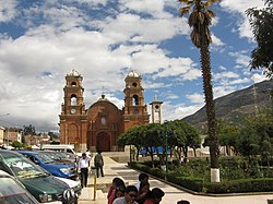
The Carhuaz District is located in the Carhuaz Province of the Ancash Region in central western Peru . The district was founded on July 25, 1857. It has an area of 194.62 km². At the 2017 census there were 15,122 residents in the district. In 1993 the population was 11,439, in 2007 13,836. The administrative seat is the provincial capital Carhuaz , located on the right bank of the Río Santa at an altitude of 2638 m .
Geographical location
The Carhuaz district stretches across the Callejón de Huaylas high valley . It has a length of 30 km in WSW-ONE direction and extends from the main ridge of the Cordillera Negra in the west to the main ridge of the Cordillera Blanca in the east. There the 6122 m high Hualcán rises . The far east of the district lies within the Huascarán National Park .
The Carhuaz district borders in the northwest on the districts Ataquero , Tinco and Shilla , in the extreme northeast on the district Chacas ( province Asunción ), in the southeast on the districts Marcará , Acopampa and Anta and in the extreme southwest on the districts Pariacoto ( province Huaraz ) and Shupluy ( Yungay Province ).
Web links
- Municipalidad Provincial de Carhuaz
- Peru: Region Ancash (provinces and districts) at www.citypopulation.de


