Yungay District
| Yungay District | |
|---|---|
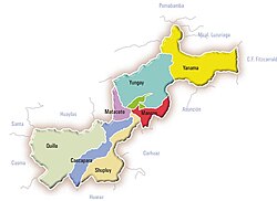
 The district of Yungay (marked turquoise) is located in the central north of the province of Yungay |
|
| Basic data | |
| Country | Peru |
| region | Ancash |
| province | Yungay |
| Seat | Yungay |
| surface | 276.7 km² |
| Residents | 20,070 (2017) |
| density | 73 inhabitants per km² |
| founding | October 28, 1904 |
| ISO 3166-2 | PE-ANC |
| Website | muniyungay.gob.pe (Spanish) |
| politics | |
| Alcalde Provincial | Fernando Ciro Casio Consolación (2019-2022) |
| Political party | Movimiento Independiente Regional Río Santa Caudaloso |
| Laguna Chinancocha | |
Coordinates: 9 ° 8 ′ S , 77 ° 45 ′ W
The Yungay District is located in the Yungay Province in the Ancash region in western Peru . The district founded on October 28, 1904 has an area of 276.68 km². At the 2017 census, there were 20,070 residents in the Yungay district. In 1993 the population was 17,324, in 2007 20,075. The administrative seat is the small town of Yungay located in the high valley Callejón de Huaylas not far from the right bank of the Río Santa at an altitude of 2,458 m .
Geographical location
The Yungay District is located in the central north of the Yungay Province. It has a lengthwise extension in SW-NE direction of 25 km. The Río Santa flows north along the southwestern district boundary. The district extends over the river valleys whose right tributaries Quebrada Llanganuco and Quebrada Huaytapallana. In the Llanganuco Valley are the lakes Laguna Orconcocha and Laguna Chinancocha. The glaciated Nevado Huascarán , at 6768 m the highest mountain in the Cordillera Blanca , rises on the eastern border of the district. Other mountains that frame the district are: Chopicalqui ( 6354 m ), Yanapaqcha ( 5460 m ), Chacraraju ( 6108 m ), Pisco ( 5765 m ) and Huandoy ( 6395 m ). The part of the district in the Cordillera Blanca lies within the Huascarán National Park .
The Yungay district borders in the northwest on the Caraz district ( Huaylas province ), in the northeast on the Yanama district , in the east on the Shilla district ( Carhuaz province ), in the south on the Mancos district and in the southwest on the Ranrahirca , Matacoto and Pueblo districts Libre (the latter in the Huaylas Province).
Web links
- Municipalidad Provincial de Yungay
- Peru: Region Ancash (provinces and districts) at www.citypopulation.de

