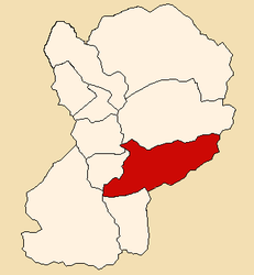
Caraz district
| Caraz district | |||
|---|---|---|---|
 Location of the district in Huaylas Province |
|||
| Symbols | |||
|
|||
| Basic data | |||
| Country | Peru | ||
| region | Ancash | ||
| province | Huaylas | ||
| Seat | Caraz | ||
| surface | 246.5 km² | ||
| Residents | 24,128 (2017) | ||
| density | 98 inhabitants per km² | ||
| founding | December 19, 1825 | ||
| ISO 3166-2 | PE-ANC | ||
| Website | www.municaraz.gob.pe (Spanish) | ||
| politics | |||
| Alcalde Provincial | Esteban Zósimo Florentino Tranca (2019-2022) |
||
| Political party | Movimiento Regional El Maicito | ||
Coordinates: 9 ° 3 ′ S , 77 ° 49 ′ W
The Caraz district is located in the southeast of the Huaylas Province in the Ancash region in western Peru . The district founded on December 19, 1825 has an area of 246.52 km². At the 2017 census, there were 24,128 residents in the Caraz district. In 1993 the population was 19,134, in 2007 23,580. The administrative seat is the city of Caraz , located in the high valley of Callejón de Huaylas on the right bank of the Río Santa at an altitude of 2285 m .
The Caraz district has a longitudinal extension in the WSW-ONO direction of 33 km. In the east, the district includes the valley of the Río Parón in the Cordillera Blanca with the glacial lake Laguna Parón . In the far east rises the 5885 m high mountain Nevado Pirámide , in the south the 6395 m Huandoy . In the west the district extends to the watershed of the Cordillera Negra .
The Caraz District is bordered by the Santa Cruz District to the north, the Yanama District to the east, the Yungay District (both in the Yungay Province ) to the south, the Pueblo Libre District to the southwest , and the Pamparomás , Huata and Districts to the west Mato .
Web links
- Municipalidad Provincial de Huaylas
- Peru: Region Ancash (provinces and districts) at www.citypopulation.de
- INEI Perú


