Cascapara District
| Cascapara District | |
|---|---|
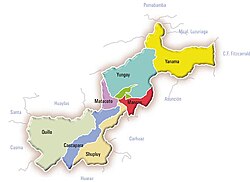
 The Cascapara district (marked cobalt blue) is located in the southwest of the Yungay province |
|
| Basic data | |
| Country | Peru |
| region | Ancash |
| province | Yungay |
| Seat | Cascapara |
| surface | 137 km² |
| Residents | 1748 (2017) |
| density | 13 inhabitants per km² |
| founding | November 29, 1915 |
| ISO 3166-2 | PE-ANC |
| politics | |
| Alcalde District | Pablo Cesar Berillo Figueroa (2019-2022) |
Coordinates: 9 ° 14 ′ S , 77 ° 43 ′ W
The Cascapara district is located in the Yungay Province in the Ancash region in western Peru . The district founded on November 29, 1915 has an area of 137 km². The 2017 census counted 1748 inhabitants. In 1993 the population was 1744, in 2007 it was 2064. The administrative seat is the town of Cascapara at an altitude of 2725 m with 168 inhabitants (as of 2017). Cascapara is located 10 km south-southeast of the provincial capital Yungay .
Geographical location
The Cascapara District is located in the southwest of the Yungay Province. It stretches across the Cordillera Negra . The south-west of the district is crossed by the Río Putaca, the right source river of the Rìo Yaután , and drained to the south-west. The northeastern part of the district lies east of the watershed in the catchment area of the Río Santa .
The Cascapara district borders in the southwest with the districts Cochabamba and Yaután district , in the northwest with the district Quillo , in the north with the districts Pueblo Libre and Matacoto and in the east and south with the district Shupluy .
Web links
- Peru: Region Ancash (provinces and districts) at www.citypopulation.de
- INEI Perú