Quillo District
| Quillo District | |
|---|---|
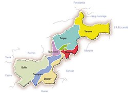
 The Quillo District (marked pale green) is located in the west of the Yungay Province |
|
| Basic data | |
| Country | Peru |
| region | Ancash |
| province | Yungay |
| Seat | Quillo |
| surface | 373.8 km² |
| Residents | 11,629 (2017) |
| density | 31 inhabitants per km² |
| founding | January 2, 1857 |
| ISO 3166-2 | PE-ANC |
| politics | |
| Alcalde District | Fortunato Santos Caballero Lacho (2019-2022) |
| Political party | Movimiento Independiente Regional Áncash a la Obra |
Coordinates: 9 ° 20 ′ S , 78 ° 3 ′ W
The Quillo district is located in the north-west of the Yungay Province in the Ancash region in western Peru . The district founded on January 2, 1857 has an area of 373.83 km². At the 2017 census, 11,629 people lived in the Yungay district. In 1993 the population was 9619, in 2007 it was 12,080. The administrative center is the town of Quillo, at an altitude of 1252 m , with 683 inhabitants (as of 2017).
Geographical location
The Quillo District is located in the west of the Yungay Province. It has a longitudinal extent in the WSW-ONE direction of 28.5 km. The district lies in the Cordillera Negra west of the watershed . It includes the upper catchment area of the Río Sechín and, in the southwest, the upper catchment area of the Quebrada Caqui, a tributary of the Río Casma .
The Quillo district is bordered to the north by the district Pamparomás ( province Huaylas ), in the northeast on the district Pueblo Libre (also province Huaylas), the east and southeast of the district Cascapara , the south by the district Yaután , the west by the district Buena Vista Alta (the last two in the province of Casma ) and in the northwest to the district of Moro ( province of Santa ).
Web links
- http://muniquillo.com/ - Municipalidad Distrital de Quillo
- Peru: Region Ancash (provinces and districts) at www.citypopulation.de
- INEI Perú