Shupluy District
| Shupluy District | |
|---|---|
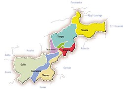
 The Shupluy District (marked pale yellow) is located in the southwest of the Yungay Province |
|
| Basic data | |
| Country | Peru |
| region | Ancash |
| province | Yungay |
| Seat | Shupluy |
| surface | 162.2 km² |
| Residents | 1840 (2017) |
| density | 11 inhabitants per km² |
| founding | January 2, 1857 |
| ISO 3166-2 | PE-ANC |
| politics | |
| Alcaldesa district | Rita Edith Atanacio Romero (2019-2022) |
| Political party | Movimiento Independiente Regional Río Santa Caudaloso |
| View of the Guitarrero cave | |
Coordinates: 9 ° 13 ′ S , 77 ° 42 ′ W
The Shupluy district is located in the Yungay Province in the Ancash region in western Peru . The district founded on January 2, 1857 has an area of 162.21 km². At the 2017 census, 1,840 people lived in the Shupluy district. In 1993 the population was 2278, in 2007 it was 2285. The administrative center is the town of Shupluy with 198 inhabitants , located in the high valley of Callejón de Huaylas on the right bank of the Río Santa at an altitude of 2538 m (as of 2017).
Geographical location
The Shupluy District is located in the southwest of the Yungay Province. It has a longitudinal extension in SW-NE direction of 32 km. In the northeast part of the district is the valley of the Quebrada Poncos, a left tributary of the Río Santa. The latter forms the north-eastern district boundary over a length of 5.5 km. In the far north of the district is the Guitarrero Cave , which was inhabited by people 12,600 years ago. The southwestern part of the district lies in the headwaters of the Río Yaután , which drains it in a southwestern direction. The Cordillera Negra watershed, which is around 4500 m high in the district, separates the two parts of the district. The Shupluy district essentially extends over a sparsely populated, relatively dry mountain region.
The Shupluy district borders on the Cascapara district to the west , the Matacoto and Mancos districts to the north, the Ataquero and Carhuaz districts (both in the Carhuaz province ) and the Pariacoto and Cochabamba districts (both in the Huaraz province ) to the east . In the extreme south, the Shupluy district borders on the Yaután district ( Casma province ).
Web links
- Peru: Region Ancash (provinces and districts) at www.citypopulation.de
