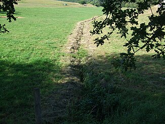
Röderbach (Arnsbach)
| Roederbach | ||
|
The Röderbach |
||
| Data | ||
| Water code | DE : 24848126 | |
| location | Hochtaunuskreis , Darmstadt District , Hesse , Germany | |
| River system | Rhine | |
| Drain over | Arnsbach → Usa → Wetter → Nidda → Main → Rhine → North Sea | |
| source | in the eastern Hintertaunus north of Neu-Anspach - Hausen-Arnsbach 50 ° 19 ′ 46 ″ N , 8 ° 29 ′ 11 ″ E |
|
| Source height | 395 m above sea level NN | |
| muzzle | in Neu-Anspach - Hausen-Arnsbach in the Arnsbach Coordinates: 50 ° 18 ′ 59 ″ N , 8 ° 29 ′ 54 ″ E 50 ° 18 ′ 59 ″ N , 8 ° 29 ′ 54 ″ E |
|
| Mouth height | 318 m above sea level NN | |
| Height difference | 77 m | |
| Bottom slope | 41 ‰ | |
| length | 1.9 km | |
| Flowing lakes | Grünwiesenweiher | |
The Röderbach is a creek almost two kilometers long. It is a left and northern tributary of the Arnsbach in the Hessian Hochtaunuskreis .
geography
course
The Röderbach rises in the eastern Hintertaunus at an altitude of about 395 m above sea level. NN in a mixed forest north of the Neu-Anspach district of Hausen-Arnsbach . It first flows in a south-easterly direction through forest terrain, then crosses under the B 275 , shortly afterwards it feeds a small, nameless pond and immediately afterwards the green meadow pond . It then runs south through a green strip and finally flows into the Neu-Anspach district of Hausen-Arnsbach at an altitude of about 318 m above sea level. NN from the left into the Arnsbach .
Usa River System
Individual evidence
- ↑ a b Google Earth
- ↑ Water map service of the Hessian Ministry for the Environment, Climate Protection, Agriculture and Consumer Protection ( information )
Web links
- The Röderbach on WFD Hessen
