List of flowing waters in the USA river system
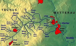
The list of rivers in the Usa river system includes all direct and indirect tributaries of the Usa , insofar as they are named on the topographic map 1: 25,000 Hessen (TK 25) , on the property map of the Hessenviewer or in the map service system of the Hessian State Office for Nature Conservation, Environment and Geology ( HLNUG) WFD in Hessen . Other source works are documented separately in the individual references. Nameless inlets and branches are not taken into account. If the river name changes after the confluence of two river sections, the two tributaries are listed separately as source tributaries, otherwise the sub-area name appears in brackets. The length specifications are rounded to one decimal place. The rivers are listed downstream. The orographic directional information refers to the directly superior body of water.
United States
The USA is a 34.0 km long right tributary of the Wetter in Hessen .
Tributaries
- Direct and indirect tributaries of the United States downstream from source to estuary
Name, ( orographic location ), length in kilometers (km), catchment area in square kilometers (km²), mean discharge (MQ) in liters per second (l / s)
- Ansbach ( left ), 1.2 km
-
Heisterbach ( right ), 1.3 km
- Struthgraben ( right ), 0.5 km
-
Arnsbach ( left ), 4.0 km, 10.8 km², 98.3 l / s
- Forstbach ( left ), 1.7 km
- Röderbach ( left ), 1.9 km
-
Häuserbach ( right ), 3.5 km
- Spießbach (GKZ: 248481284) ( right ), 0.9 km
- Eisenbach ( right ), 1.4 km
- Bondenbach ( left ), 0.7 km
- Schleichenbach ( left ), 1.9 km
- Schlichenbach ( right ), 1.3 km
- Mühlgraben ( left ), 1.0 km
-
Stockheimer Bach ( left ), 5.2 km, 10.6 km², 92.4 l / s
- Kertenbach ( right ), 0.9 km
-
Röllbach ( right ), 2.4 km
- Kittelbach ( right ) (1.4 km)
-
Eschbach ( left ), 5.0 km, 9.0 km²
- Regengraben ( right ), 0.5 km
- Dittenbach ( left ), 1.5 miles
-
Michelbach ( left ), 8.1 km, 15.2 km², 89.4 l / s
- Markbach ( left ), 1.1 km
- Schmalbach ( right ), 1.6 km
-
Wiesbach ( right ), 6.7 km, 15.5 km², 132.1 l / s
-
Erlengraben ( left ) 1.8 km
- Erlenbach ( left ), 0.8 km
- Pfingstborner Bach ( Bach von der Kapersburg ) ( right ), 2.1 km
- Waschbach ( left ), 0.8 km
- Bach from Rothwies ( left ), 1.0 km
-
Erlengraben ( left ) 1.8 km
- Holzbach ( right ), 6.1 km, 7.8 km², 65.2 l / s
- Detzelbach ( left ), 1.2 km
- Forbach ( left ), 4.3 km, 8.0 km², 35.7 l / s
- Dümmelbach ( right ), 0.8 km
-
Vogelthal-Bach ( right ), 2.4 km
- Schwarzloch-Bach (GKZ 248485362) ( left ), 1.4 km
- Schiefertalbach (TVC: 24848552) ( right ), 1.2 km
- Aitzenbach ( right ), 4.3 km, 4.1 km², 31.6 l / s
- Hainbach ( right ), 1.9 km, 3.1 km², 17.9 l / s
-
Fauerbach ( left ), 9.7 km, 17.2 km², 79.5 l / s
- Issel ( left ), 1.6 miles
- Riedgraben ( left ), 1.6 km
- Steinlachsgraben ( right ), 1.2 km
- Blüßengraben ( right ), 2.1 km
- Säckelgraben (left), 5¼ km
-
Deutergraben ( right ), 4.0 km
- Stuhlgraben ( left ), 1.0 km
-
Seebach ( Leihgraben ) ( right ), 6.7 km, 11.8 km², 43 l / s
- Weilerwiesengraben ( left ), 1.5 km
- Riedgraben ( left ), 1.5 km
River system weather
References and comments
- ↑ Course of the Spießbach on the OpenTopoMap
- ^ For WFD: Eisenbach
- ↑ a b c According to field names
- ↑ Course of the Dümmelbach on the OpenTopoMap
- ↑ course of Dümmelbachs on the WFD Viewer
- ↑ Course of the Schwarzloch-Bach on the OpenTopoMap
- ^ Course of the black hole brook on the WFD Viewer
- ↑ OpenTopoMap
- ^ WFD Viewer
- ^ Name at Hessenviewer
- ↑ GKZ 24848692
- ↑ Measured in the WFD Viewer
- ↑ Upper heading name
Web links
- Hessenviewer (Geoportal Hessen) of the Hessian State Office for Soil Management and Geoinformation with property mapping ( notes )
- Water map service of the Hessian Ministry for the Environment, Climate Protection, Agriculture and Consumer Protection ( information )


