
Detzelbach
| Detzelbach | ||
 River system of the USA |
||
| Data | ||
| Water code | DE : 24848512 | |
| location |
Taunus
|
|
| River system | Rhine | |
| Drain over | Usa → Weather → Nidda → Main → Rhine → North Sea | |
| source | in Hintertaunus , northwest of the Kerner Berg 50 ° 22 '5 " N , 8 ° 35' 31" O |
|
| Source height | approx. 290 m above sea level NHN | |
| muzzle | north of Holzberg in the USA Coordinates: 50 ° 21 ′ 35 " N , 8 ° 35 ′ 53" E 50 ° 21 ′ 35 " N , 8 ° 35 ′ 53" E |
|
| Mouth height | approx. 213 m above sea level NHN | |
| Height difference | approx. 77 m | |
| Bottom slope | approx. 64 ‰ | |
| length | 1.2 km | |
 From behind, north, the Detzelbach plunges over the remains of the fortifications of the creek bed into the meander of the United States, which flows from west to east |
||
The Detzelbach is a one kilometer long left and northern tributary of the United States .
geography
course
The Detzelbach rises in the Hintertaunus in the Hessian Hochtaunuskreis , northwest of the Kernersberg , and flows north of the Holzberg into the USA.
The source is at a crossroads in the western part of the Kernerstriesch parcel , which is used as a field outside the nature reserve . The course of the brook initially leads in a wide arc open to the west in a south-easterly direction through a meadow with source outlets that feed the brook and an old brick bridge. On the western flank of the Kernersberg , the brook, now flowing south, penetrates into what is now the edge of the forest. Its bed is artificially attached and consists of narrow quarry stones made of quartzite slate placed on edge in a V shape, a total of about 200 m in length, up to the outlet of the pond, where the stream bed is made of paving stones. Just a few years after the start of the upgraded section, the artificial bed no longer holds the stream, it flows right and left past the channel that has been set.
The Detzelbach now flows in a south-westerly direction and feeds a pond. In doing so, it makes another arch around the Kernersberg , this time open to the east , flows past a branch reminiscent of a bleached whale frame and leaves the edge of the forest. It flows through the meadow with reed plants and herbs to the western edge of the forest and in a left and right curve under the path at the southern end of the meadow. It tumbles down a masonry channel at the beginning of the 20-25 m long piping to a sewer shaft on the northern edge of the B 275, which absorbs surface runoff and passes it under the B 275 and a dirt road in a 20 m long pipe, traverses it briefly , about 10 m long, a meadow in the Usa floodplain and falls over a no longer intact fortification of its stream bed coming from the north from the left into the USA , which here, flowing eastwards, has formed a meander to the north.

Detzelbach, dried up, at its dried up source before crossing under a path before the northwestern beginning of the NSG in Kernerstriesch

Sewer shaft on the northern side of the B 275

At the lower end of the NSG, the Detzelbach comes from the western edge of the forest

From the site of the former Kreuzmühle, the stream water tumbles down the steep slope southwards through a masonry channel into a pipe


Historical course
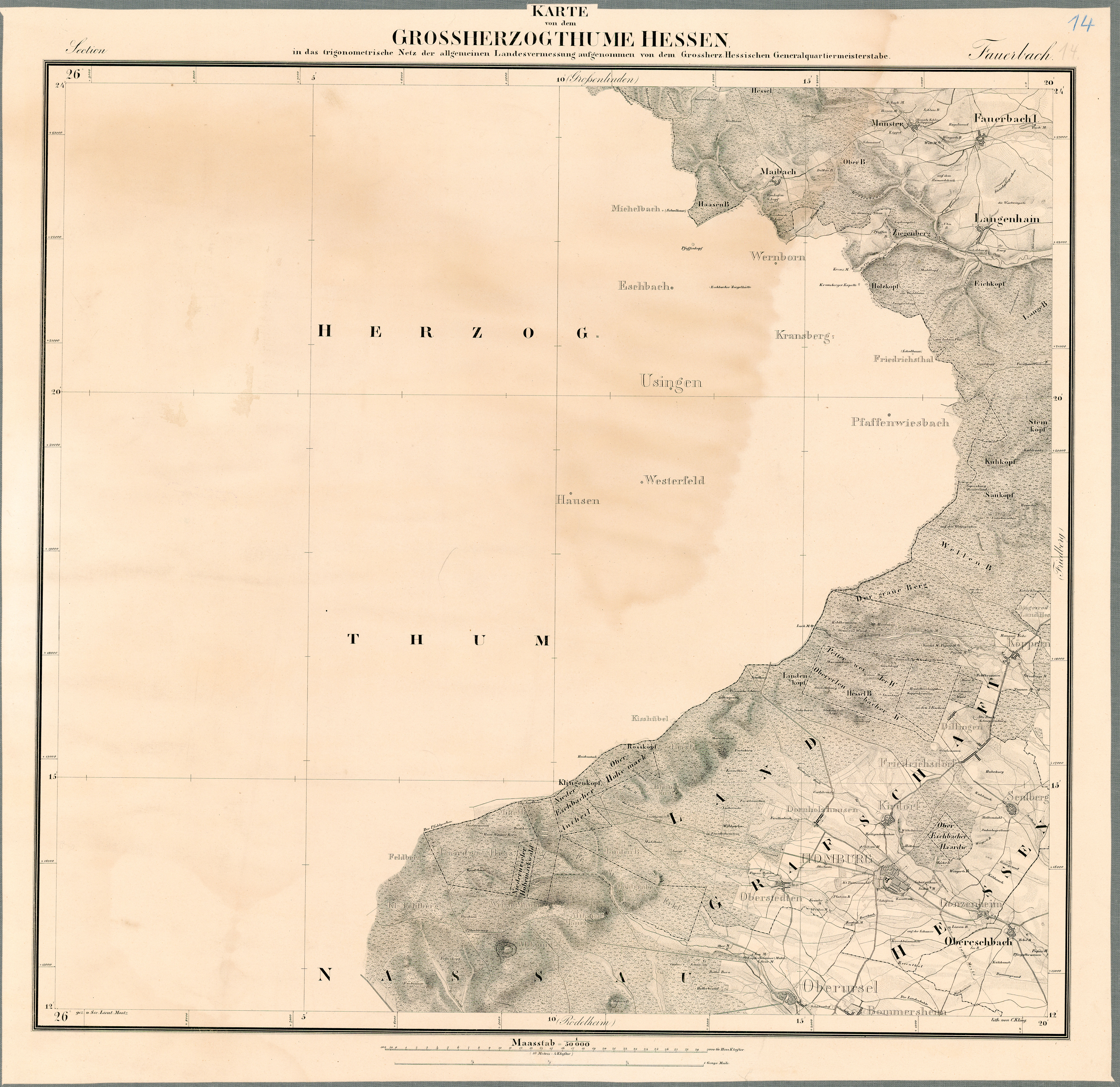
The State Historical Information System of Hesse (LAGIS) provides the public with historical maps, among other things. The map of the Grand Duchy of Hesse 1: 50,000 (1823–1850), sheet no. 14 Fauerbach is of importance for the Detzelbach . This map shows the Detzelbach flowing freely in the middle of a meadow, where there is a pond today, and a mill at the valley exit, the Kreuzmühle . The map also shows a different course of the brook at the foot of the Kernersberg and through the Usaaue to the confluence with the Usa. Today the old creek bed can still be seen at the foot of the Kernersberg , to the east of today's steep and walled drainage channel, which leads to a barred sewer shaft to absorb any surface runoff, as well as the old course through the Usaaue. The swiveling of the stream in the meadow from the middle of today's NSG to its western edge is well represented. From this, for example in Google Earth or from the path in the western edge of the forest, at the same time the western border of the NSG, the stream bed, which is now dry, can still be seen, as well as the section at the edge of the forest to the current course of the stream.
The Detzelbachtal near Wernborn is a nature reserve .
Usa River System
Individual evidence
- ↑ a b Google Earth
- ↑ Water map service of the Hessian Ministry for the Environment, Climate Protection, Agriculture and Consumer Protection ( information )
- ^ State Historical Information System Hesse (LAGIS) .
- ↑ Historical maps .
- ↑ Map of the Grand Duchy of Hesse: included in the trigonometric network of general land surveying by the Grand Ducal Hessian Quartermaster General .
- ↑ Grand Duchy of Hesse 1823-1850 (overview map with handwritten additions) - 14. Fauerbach. Historical maps. In: Landesgeschichtliches Informationssystem Hessen (LAGIS).
- ^ Map of the Grand Duchy of Hesse .
- ↑ View from the eastern path up into the valley with herbs and reed beds