
Etzbach (Forbach)
| Etzbach | ||
 River system of the USA |
||
| Data | ||
| Water code | DE : 24848522 | |
| location |
Taunus
|
|
| River system | Rhine | |
| Drain over | Forbach → Usa → Wetter → Nidda → Main → Rhine → North Sea | |
| source | in the eastern Hintertaunus northeast of Butzbach - Maibach 50 ° 23 ′ 9 ″ N , 8 ° 35 ′ 9 ″ E |
|
| Source height | 352 m above sea level NHN | |
| muzzle | south of Butzbach- Wiesental in the Forbach Coordinates: 50 ° 22 '38 " N , 8 ° 36' 54" E 50 ° 22 '38 " N , 8 ° 36' 54" E |
|
| Mouth height | 230 m above sea level NHN | |
| Height difference | 122 m | |
| Bottom slope | 44 ‰ | |
| length |
Name strand: 2.8 km main strand with OL Krebsbach : |
|
| Catchment area | approx. 4.4 km² | |
 Stony bed and clear water of the Etzbach |
||
The Etzbach is a creek almost three kilometers long on the name strand in the eastern Hintertaunus in the district of Butzbach in the Hessian Wetteraukreis , which flows from the right into the Forbach when coming from the west . On the main hydrological strand, which instead of its name upper reaches its more important tributary Krebsbach , it has a length of 3.7 km.
geography
course
The Etzbach rises northeast of Butzbach- Maibach on the edge of a large northeastern bay of the clearing island around Butzbach-Maibach between the southern slope of the Nollkopf spur in the north and the Oberberg ( 343 m above sea level ) in the east. Its highest source is on the edge of a mixed forest at an altitude of about 352 m above sea level. NHN , right next to the district road K 15 from Maibach to the northeast to L 3353 at the Hubertus youth hostel or the source of the Forbach .
The stream initially flows in a south-easterly direction and leaves the forest after about 100 meters to follow the edge of the forest. He then makes a gentle curve to the right through the corridors In der Etzbach and then Wellboden, walking in a narrow strip of green between the mixed forest area around the Oberberg on his left and the areas initially used for arable farming below the Maibacher (Kirch-) Weg as meadow the said bay on his right. Three more springs in the forest, which flow in from the left, and one in the meadow, which flows in from the right, supply him with water. Below the Maibacher (Kirch-) Weg the Etzbach flows freely accessible through the meadow and only occasionally dives into a thicket at the edge of the forest. About 250 meters before the mouth of the Krebsbach, a last flat spring drains into it from the right (in the hot summer of 2018 the one that keeps it flowing up to the mouth), which is now inaccessible in the edge of the forest. After a little over a kilometer, now on the southern course, it unites at the Gewann Am Pferdekopf under the forest with the Krebsbach coming from the right and west , which is almost twice as long as the Etzbach up to now and its own catchment area up to this point even by the factor three surpasses.
The combined brook, which roughly continues the direction of the inflow of the Krebsbach, now flows in a long and flat arc to the southeast through a larger forest area with the mountain forests around the Oberberg on the north bank and the Gewann Filshard on the south bank. It first moves about 300 meters through a coniferous forest strip, then through a mixed forest area. About 700 meters southwest of the barrel is a barrow a little beyond the watershed. About 800 meters after the confluence, it reaches the southernmost point of its course, then begins the second part of the arch, at the end of which, after another 600 meters, it feeds an approximately 0.3 hectare pond.
After this, it crosses under the K 254 district road - piped since the last pond - a little south of the outskirts of the Butzbach district of Wiesental and finally flows out at an altitude of about 230 m above sea level. NHN from the west into the Forbach coming from Wiesental . (Although it looks rather the other way around, because the Forbach forms several arms through which it unites with the Etzbach. And it can dry out. In the dry and hot summer of 2018, the Forbach dried up about 100 meters before the Etzbach .)
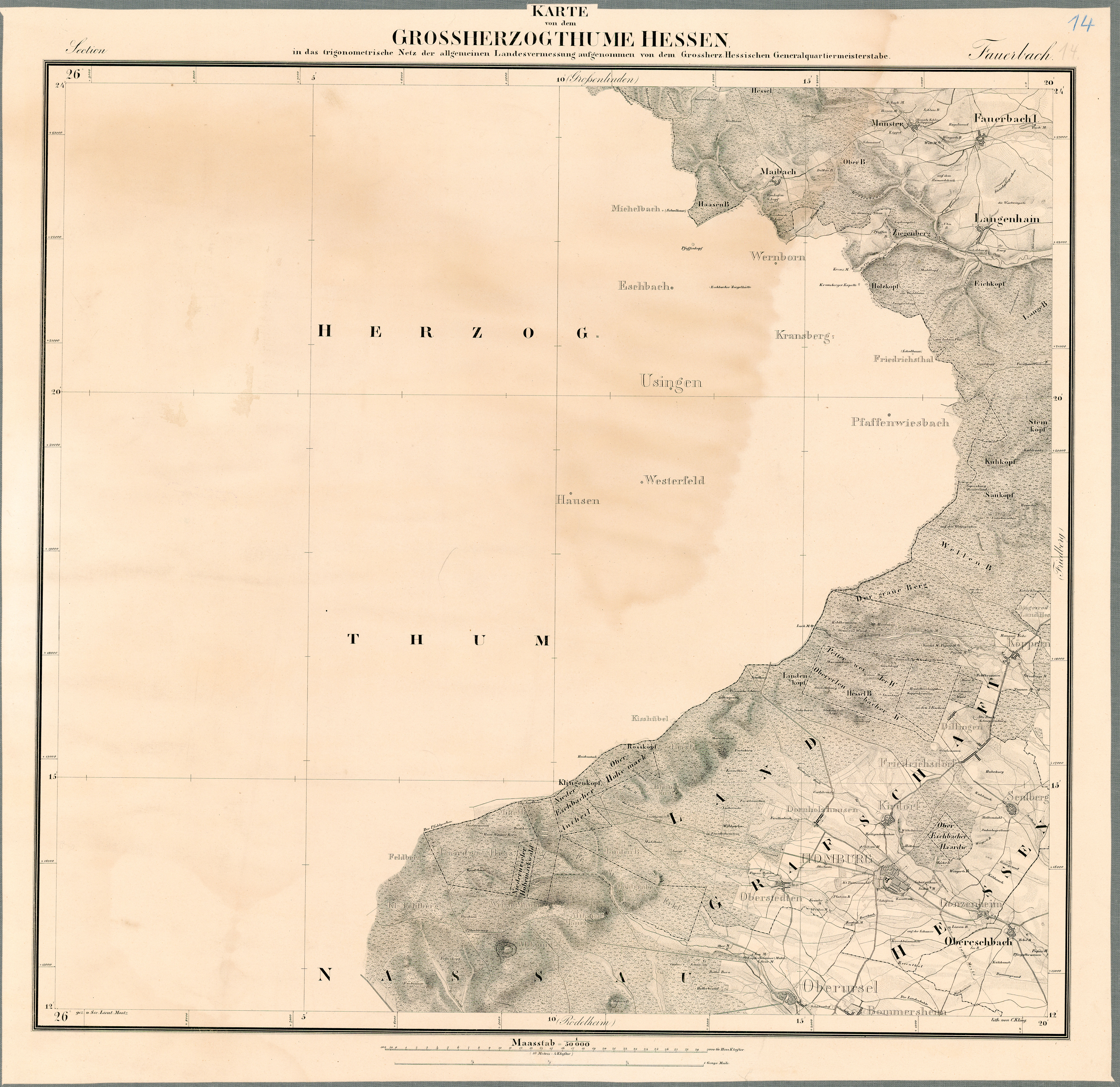
Historical course
The State Historical Information System of Hesse (LAGIS) provides the public with historical maps, among other things. For the Etzbach of concern which is a map of the Großherzogthume Hesse 50,000 (1823 to 1850), Journal. 14: 1 Fauerbach . This map shows the Etzbach springing under the Maibacher (Kirch-) Weg and flowing freely through a meadow. After merging with the Krebsbach, it flows through the wave bottom , an elongated meadow between the Oberberg in the north and an unnamed mountain range in the south. The large fish pond in front of the Forbach estuary does not yet exist, and neither does Wiesental.
Tributaries
- Krebsbach ( right )
Usa River System
References and comments
- ↑ a b Hessenviewer (Geoportal Hessen) of the Hessian State Office for Soil Management and Geoinformation with property mapping ( notes )
- ↑ Water map service of the Hessian Ministry for the Environment, Climate Protection, Agriculture and Consumer Protection ( information )
- ↑ Length 1.) Running water 248485224 + 2.) Running water 24848522 from confluence from 1.)
- ↑ Length measured on the Hessenviewer.
- ↑ Catchment area measured on the Hessenviewer.
- ↑ WFD Hessen combines Etzbach- Unterlauf and Krebsbach under the water code number 24848522.
- ↑ Representation of a section of the stream from the source in the WFD viewer. Retrieved August 26, 2020 .
- ^ Name "Krebsbach" according to the property map of the Hessenviewer (scale 1: 3.800 and below). The WFD Hessen regards this hydrologically more important right upper course as Etzbach and records the hydrological main line under the common water code number 24848522, while the name upper course of the Etzbach is separated there under the water body code 248485224.
- ^ State Historical Information System Hesse (LAGIS) .
- ↑ Historical maps .
- ^ Map of the Grand Duchy of Hesse .
- ↑ Grand Duchy of Hesse 1823-1850 (overview map with handwritten additions) - 14. Fauerbach. Historical maps. In: Landesgeschichtliches Informationssystem Hessen (LAGIS).
- ↑ sheet 14: Fauerbach (1: 50000) . In: Landesgeschichtliches Informationssystem Hessen (LAGIS).