Dümmelbach
| Dümmelbach | ||
|
River system of the USA |
||
| Data | ||
| Water code | DE : 24848534 | |
| location |
Taunus
|
|
| River system | Rhine | |
| Drain over | Usa → Weather → Nidda → Main → Rhine → North Sea | |
| source | Kirchwald south of Ober-Mörler district Langenhain-Ziegenberg 50 ° 21 ′ 34 ″ N , 8 ° 37 ′ 47 ″ E |
|
| Source height | approx. 280 m | |
| muzzle | southern outskirts of Langenhain-Ziegenberg Coordinates: 50 ° 21 '47 " N , 8 ° 38' 7" E 50 ° 21 '47 " N , 8 ° 38' 7" E |
|
| Mouth height | approx. 194 m | |
| Height difference | approx. 86 m | |
| Bottom slope | approx. 11% | |
| length | 800 m | |
|
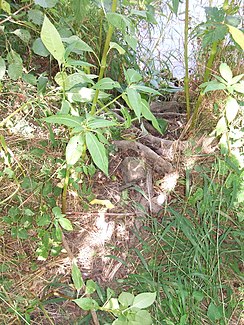
Estuary northwards into the USA via alder roots |
||
The Dümmelbach is a less than a kilometer long right and southern tributary of the United States . It does not have its own catchment area.
geography
course
The Dümmelbach rises from the sources of two spring branches running close to each other in a rift system that extends further west and higher and branches out there in a notch valley , a run or a run , in the Kirchwald south of Usa and Langenhain-Ziegenberg , a western district of Ober-Mörlen on federal highway 275 . The arched valley is made up of beeches, which show a pronounced natural regeneration. The stream first flows eastwards in a long left curve and then turns continuously in a northerly direction. In a bay on the north side of the valley slope at km 0.7 on a forest path, perhaps a former quarry, a few oaks and spruces grow . From around km 0.4 the vegetation changes and linden trees now shape it, a preparation for the pond and fish breeding facility of ASV Langenhain-Ziegenberg e. V. It consists of a square sand trap for alluvial sediment, followed by a small and three larger ponds, all of which are fed by the Dümmelbach. After that, the stream has overcome even a distance of 50 meters in the mixed forest on the slopes of nameless mountain to pass beneath an unpaved dirt road by pass and is now the last 100 meters by the United States-Aue, lined with some alders , willows and cherries until to the confluence from the right into the USA at km 16.7 opposite a grave land on the left bank.
In the Kerbtal in the Kirchwald, accumulations of alluvial debris in the mud of the creek bed show that the creek can occasionally convey many times its usual water flow to the valley, for which the fish farm is prepared with a flow around it. On the side there are a few flat groundwater outlets that are used by animals as wallows. At km 0.575, a now dry ditch opens out from the right, which reaches a height of 330 m and is longer than half a kilometer.
Usa River System
Individual evidence
- ↑ Water map service of the Hessian Ministry for the Environment, Climate Protection, Agriculture and Consumer Protection ( information )
- ↑ For the origin of the name see z. B. Station 6 of the excursion destinations by Peter Heckert
- ↑ The name Kirchwald also seems to apply to the 341 meter high mountain peak south of the Kerbtal / southwest of the source. To the east of the Holzberg am Holzbach rises the 349-meter-high Kirchwald-Westgipfel as a continuation of the mountain range to the west.

