
Bach from the Rothwies
| Bach from the Rothwies | ||
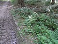
 Source in the coniferous forest of the former meadow |
||
| Data | ||
| Water code | DE : 248483294 | |
| location |
Taunus
|
|
| River system | Rhine | |
| Drain over | Wiesbach → Usa → Wetter → Nidda → Main → Rhine → North Sea | |
| source | south-southwest of Usingen - Kransberg 50 ° 20 ′ 17 ″ N , 8 ° 35 ′ 12 ″ E |
|
| Source height | 342 m above sea level NHN | |
| muzzle | in Kransberg in the Wiesbach Coordinates: 50 ° 20 ′ 51 ″ N , 8 ° 35 ′ 32 ″ E 50 ° 20 ′ 51 ″ N , 8 ° 35 ′ 32 ″ E |
|
| Mouth height | 240 m above sea level NHN | |
| Height difference | 102 m | |
| Bottom slope | 85 ‰ | |
| length | 1.2 km | |
 It flows into the Wiesbach below the Mühlweg |
||
The brook from the Rothwies is an almost 1¼ km long forest brook in the eastern Hintertaunus , which flows into the Wiesbach from the left and south-west in the district of Kransberg of the municipality of Usingen in the Hessian Hochtaunuskreis .
geography
course
The stream from the Rothwies rises at an altitude of about 340 m above sea level. NHN in a coniferous forest in a valley in the Gewann Die Rothwies , about ¼ km south of the Kreuzkapelle at the foot of the mountain Kuhardt , at the foot of which lies the village of Kransberg.

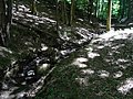
The stream initially flows along a path on its left bank and after a few meters forms an extensive hollow at a well ⊙ . A few dams below that, the stream crosses the path westwards and flows through, in a northerly direction, a transition area into the mixed forest characterized by beeches to Kransberg, which contains a few sprinkles of spruce . The previously flat valley develops into a notched valley with light, tall, old trees . At river km 0.7, the valley is crossed diagonally by the natural monument Hainbuchenallee , the dead straight avenue built from hornbeam from the cemetery at Kransberg Castle to the Kreuzkapelle . This is where a once about 250 m² pond begins, the earth dam of which is still 50 m below the avenue. At its eastern end it has a breach through which the stream can simply flow away without being dammed.
The hornbeam avenue leads up the slope on the right bank to the cemetery, on the left bank it leaves the valley quickly on a steep path. The hiking trail from the right bank changes to the left and takes the name Seufzerallee . In addition to fallen trees, its use is also hampered by the runoff from springs on the right slope, roughly just below the pierced dam. The stream begins a gentle curve to the right and flows in a north-easterly direction.

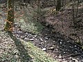
At km 0.26 flows below a passage under the Seufzerallee at an altitude of 278 m above sea level. NHN coming from the left and from its own valley an approximately ½ km long tributary, which in the slope of the Kuhardt under the bend of a forest path at 315 m above sea level. Above sea level originates from ⊙ . Less than 100 m below the estuary, an embankment begins in the valley floor with recreational sports facilities (table tennis, basketball). The brook from the Rothwies is therefore piped for a distance of 60 m. Different and older tubing ends at the outlet. The paved brook spends 40 m outdoors up to the last 150 m long piping to cross under the local main road or district road K 728 and a corner property.
Below the main road , the stream from the Rothwies flows after about 15 m on the Mühlweg road in the north of Kransberg at an altitude of about 240 m above sea level. NHN from the left and south-west into the Wiesbach flowing here to the north-west .
The 1.2 km long run ends about 102 meters below the source, so it has an average bottom gradient of about 85 ‰.
- More views from the valley of the brook from the Rothwies

Cross to the old spring
Bach & old spring (right)

Via Hainbuchenallee

Cross. Hornbeam avenue
Under hornbeam avenue

Ford tributary Avenue of sighs
Lower inflow opens

Outlet (right) leisure area


Usa River System
geology
In the headwaters and in the forest above there is a significant number of large chunks of quartz lying open and cracked on the ground. About ½ km southwest of the source, a well-known quartz vein strikes from northwest to southeast through the Taunus, which can be the source of the Brocken.
The Eschbacher cliffs are part of the vein. There are quarries to the west and northwest of the source, the one in the Usatal valley is still in operation today and quartz is mined there.
biology

Over 100 specimens of the black devil's claw live inconspicuously in and around the valley , sometimes associated with the multi-flowered white root . In the vicinity of the hornbeam avenue, the adults of various magnificent dragonflies appear.
Web links
Individual evidence
- ↑ a b c d Google Earth Pro
- ↑ Water map service of the Hessian Ministry for the Environment, Climate Protection, Agriculture and Consumer Protection ( information )
- ↑ Representation of the stream in the WFD viewer. Retrieved June 14, 2020 .
- ↑ a b c d e f g h Measured in the WFD Viewer
- ↑ Representation of the lower inflow in the WFD Viewer. Retrieved June 14, 2020 .
- ↑ Bremthaler quartzite movement. Retrieved on May 30, 2020 (informative self-presentation of the company).