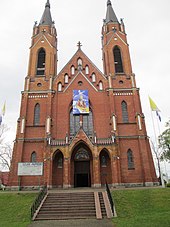
Rajgród
| Rajgród | ||
|---|---|---|

|
|
|
| Basic data | ||
| State : | Poland | |
| Voivodeship : | Podlaskie | |
| Powiat : | Grajewski | |
| Gmina : | Rajgród | |
| Area : | 25.28 km² | |
| Geographic location : | 53 ° 44 ' N , 22 ° 42' E | |
| Residents : | 1573 (June 30, 2019) | |
| Postal code : | 19-206 | |
| Telephone code : | (+48) 86 | |
| License plate : | BGR | |
| Economy and Transport | ||
| Street : | DK61 Grajewo - Augustów | |
| administration | ||
| Mayor : | Ireneusz Gliniecki | |
| Address: | ul.Warszawska 32 19-206 Rajgród |
|
| Website : | www.umrajgrod.pl | |
Rajgród ( German Raygrod , Lithuanian Raigardas , Belarusian Райгарад ) is a city in the powiat Grajewski of the Podlaskie Voivodeship in Poland . It is the seat of the town-and-country municipality of the same name with 5230 inhabitants (as of June 30, 2019).
geography
The city is located in the northeast of the Powiat and on the banks of the eastern arm of the Jezioro Rajgrodzkie , which is one of the 20 largest lakes in the country with around 15 km² . The urban area borders on the Warmian-Masurian Voivodeship in the north .
history
Rajgród received city rights in 1568 . In 1815 it became part of Congress Poland , which was ruled by the Russian Empire . After the January uprising of 1863/1864, the city rights were revoked in 1870. After the rebuilding of Poland in 1918, the city rights were renewed in 1923.
From 1975 to 1998 the place belonged to the Łomża Voivodeship .
local community
The town itself and 30 villages with school boards belong to the town-and-country community (gmina miejsko-wiejska) Rajgród.
traffic
The city is located on the national road DK61 , which leads from the district town of Grajewo to Augustów . It has been developed in sections between Warsaw and Kaunas in Lithuania as the S61 expressway on the Via Baltica (E67) .
Web links
- City and municipality website (Polish)


