Remchingen-Middle Pfinztal
|
Landscape protection area "Remchingen-Mittleres Pfinztal"
|
||
|
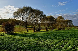
In the Rannbach valley |
||
| location | Four communities in the Enzkreis in Baden-Württemberg , Germany | |
| surface | 12.58 km² | |
| Identifier | 2.36.037 | |
| WDPA ID | 320653 | |
| Geographical location | 48 ° 58 ' N , 8 ° 34' E | |
|
|
||
| Setup date | March 12, 1987 | |
| administration | District Office Enzkreis | |
Remchingen-Mittleres Pfinztal is a protected landscape area in the Enzkreis (protected area number 2.36.037).
Location and description
The 1,258 hectare landscape protection area was created by ordinance of the Enzkreis District Office of March 12, 1987. When this ordinance came into force, the Pforzheim District Office's ordinance on the protection of parts of the landscape in the Dietlingen and Nöttingen districts of August 17, 1962 (Ranntal Landscape Protection Area) and the ordinance of the Baden Minister of Culture and Education for the Protection of Landscapes along the Reichsautobahn in the city and district of Pforzheim from February 11, 1942 ceased to be in force, insofar as these extended to the scope of this ordinance.
The protected area consists of two sub-areas and is located around the Remching districts of Nöttingen , Darmsbach , Wilferdingen and Singen on the markings of four municipalities:
- Remchingen = 1252.7089 ha, 99.58%
- Pressing = 2.3393 ha, 0.18%
- Kämpfelbach = 0.1048 ha, 0.01%
- Königsbach-Stein = 1.6792 ha, 0.13%
It belongs to the natural area 125- Kraichgau within the natural spatial main unit 12- Neckar- and Tauber-Gäuplatten . Several landscape protection areas follow. A small part of the protected area is in FFH area No. 7017-341 Pfinzgau Ost .
Protection purpose
According to the Protected Area Ordinance, the main protection purpose is conservation
- the near-natural cultural landscape typical of the Pfinzhügelland;
- of permanent green areas with no plowing;
- the meadows with their orchards and the biotopes linked to them (including forest edges, hedgerows and field trees);
- the field corridor structured by hedge trains, trees, ravines and ravines. The hedgerows, trees, bushes, fruit trees, ravines, creeks and near-natural forests as well as the vegetation of abandoned quarries and clay pits are of great importance as biological cells and as refuges for the flora and fauna, which are important for the stability of the natural balance. They also provide effective protection against wind and water erosion;
- the wetlands with their reeds, springs and spring meadows;
- the floodplains of Pfinz, Kämpfelbach, Auerbach and Rannbach with their wooded meadows;
- of forest stands, succession areas and trees, especially deciduous and mixed forests.
See also
Web links
- Profile of the landscape protection area in the protected area directory of the LUBW


