Monbach, Maisgraben and St. Leonhardquelle
|
Nature and landscape protection area Monbach, Maisgraben and St. Leonhardquelle
|
||
|
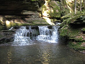
Waterfall in the Monbach Gorge |
||
| location | Neuhausen im Enzkreis and Bad Liebenzell in the Calw district in Baden-Württemberg , Germany | |
| surface | 42 ha | |
| Identifier | 2115 | |
| WDPA ID | 163175 | |
| Geographical location | 48 ° 48 ' N , 8 ° 45' E | |
|
|
||
| Setup date | December 14, 1988 | |
| administration | Karlsruhe Regional Council | |
| particularities | 2 sub-areas | |
The nature and landscape protection area Monbach, Maisgraben and St. Leonhardquelle is located in the Baden-Württemberg municipalities of Neuhausen im Enzkreis and Bad Liebenzell ( Möttlingen mark ) in the Calw district , it consists of two sub-areas.
Characteristics
The area was designated as a nature and landscape protection area by ordinance of the Karlsruhe regional council of December 14, 1988. The NSG is listed under the protected area number 2.115, it is around 42 hectares and is located equally in the district of Calw and in the Enzkreis. The LSG has two numbers, 2.35.044 for the area of the district of Calw (149.4 hectares) and 2.36.042 for the 79.5 hectare part that is in the Enzkreis. The CDDA code for the nature reserve is 164657 and corresponds to the WDPA ID .
location
The protected areas are roughly halfway between the towns of Bad Liebenzell and Neuhausen and encompass the entire open corridor of the Maisgraben and Monbach valley system east of the Unterhaugstett-Neuhausen road and the predominantly wooded gorge up to the confluence with the Nagold.
The nature reserve has a size of 42.0 hectares. The 228.9 hectare protected landscape area of the same name serves as an additional area. To the northeast, the nature and landscape protection area borders on the 1,936 hectare landscape protection area 2.36.041 Neuhausen-Biet . The northern NSG sub-area is part of the 1,902 hectare FFH area No. 7118-341 Würm-Nagold-Pforte, while the southern NSG sub-area is part of the 2,046 hectare FFH area No. 7218-341 Calwer Heckengäu .
The nature and landscape protection area is located in the natural areas 122 - Obere Gäue and 150 - Black Forest edge plates within the natural spatial main units 12 - Gäuplatten in Neckar and Tauberland and 15 - Black Forest .
Protection purpose
The protection purpose is both the preservation and securing of a historically unique spring formation in the Muschelkalk (St. Leonhardquelle) with its typical and species-rich animal and plant communities (reeds and sedge area, surrounded by globeflower brook thistle meadows) and the preservation and securing of the steep, rocky rocky sea "Slopes of the valley floor and the water cascades of the red sandstone gorge of the Monbaches with its species-rich fern-fir-beech forest leading to the canyon and tall herbaceous forest.
See also
- List of nature reserves in the Enzkreis
- List of nature reserves in the district of Calw
- List of landscape protection areas in the Enzkreis
- List of landscape protection areas in the district of Calw
literature
- District Office for Nature Conservation and Landscape Management Karlsruhe (Ed.): The nature reserves in the administrative district of Karlsruhe . Thorbecke, Stuttgart 2000, ISBN 3-7995-5172-7
Individual evidence
- ↑ Map services of the Federal Agency for Nature Conservation ( information )
- ^ Alfred G. Benzing: Geographical land survey: The natural space units on sheet 170 -Stuttgart. Federal Institute for Regional Studies, Bad Godesberg 1964. → Online map (PDF; 4.1 MB)
Web links
- Profile of the nature reserve in the LUBW's list of protected areas
- Profile of the landscape protection area in the protected area directory of the LUBW (Enzkreis)
- Profile of the landscape protection area in the protected area directory of LUBW (Calw district)


