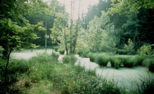
Alder, Metten and Gründelbach lowlands
|
Nature and landscape protection area "Erlen-, Metten- and Gründelbachniederung"
|
||
| location | Municipalities of Ötisheim and Ölbronn-Dürrn in the Enzkreis in Baden-Württemberg , Germany | |
| surface | 2.77 km² | |
| Identifier | 2221 | |
| WDPA ID | 320575 | |
| Geographical location | 48 ° 58 ' N , 8 ° 47' E | |
|
|
||
| Setup date | 1986 | |
| administration | Karlsruhe Regional Council | |
The nature and landscape protection area Erlen-, Metten- and Gründelbachniederung lies in the area of the communities Ötisheim and Ölbronn-Dürrn in the Enzkreis in Baden-Württemberg .
Characteristics
The area was designated as a nature reserve under the protection area number 2092 by ordinance of the Karlsruhe regional council of June 30, 1986. This ordinance came into force on October 31, 1986 when it was published in the Law Gazette for Baden-Württemberg. The CDDA code is 320575 and corresponds to the WDPA ID .
location
The protected area lies between Ötisheim and Ölbronn-Dürrn. The nature and landscape protection area 2221- Bauschlotter Au borders immediately to the west. Almost all of it belongs to the FFH area No. 7018-342 Enztal near Mühlacker . It is located in the natural areas 124- Strom- and Heuchelberg and 125- Kraichgau within the natural spatial main unit 12- Neckar- and Tauber-Gäuplatten .
The protected area is characterized by a variety of natural habitats, with differently equipped wet meadows and forest cover. By alternating between oak and hornbeam forests, oak forests, ponds and open meadow areas, it offers a habitat for a diverse fauna.
Nature reserve
The nature reserve is about 165 hectares and consists of 6 parts. In the Ölbronn-Dürrn area you will find the Henkersklinge (approx. 4.6 hectares of land ) with parts of the Mühlau forest (approx. 8.8 hectares of forest) and the forest below the Eichelberg (approx. 36.2 hectares of forest). In the Ötisheim area there is the Schanzenhau, the Buchrain and the Hellerwald (approx.42.4 hectares of forest) with the Erlenbach lowlands in front of and behind the Hürstwald (approx.27.5 hectares of forest) and parts of the Hürstwald (approx ha of forest), the Allmendwiesen (approx. 29.5 ha), Ob Corres (approx. 6.6 ha) and the Eissee (approx. 0.53 ha).
Landscape protection areas
The nature reserve L1 is 70 hectares in size. In the Ötisheim area these are: Sommerhau, Herdwiesen, Trieb, Riedwiesen, Hinter dem Hürstwald, Vor dem Hürstwald, Langwiesen, Unter dem Dürrner Weg, Rosenberg, Beim Großer Brunnen, Hundsücken, Kalbwiesen, Ob dem Großer Brunnen and Großer Brunnen. In Ölbronn-Dürrn the Binsenplatte, the zoo and the forest meadows.
The landscape protection area L2 is 215 hectares. There are in the Ötisheim area, as a corridor, in whole or in part: the Unter dem Eckhau, Baudenwiesen, Oberste Wiese, Herdwiesen, Hürstspitzen, Allmendwiesen, Unter dem Dürrner Weg, Wirsenäcker, Kohlplatte, Ob dem Brücklesweg, Wiesenäcker, Unter dem Brücklesweg, Mettenbach and Gründelbach. As a forest, Schanzenhau, Buchrain, Hellerwald and the municipal forests Eichelberg and Hürstwald belong in whole or in part. In the Dürrn district, as a corridor, these are in whole or in part: Mühlau, Grün, Sommerhau, Steckwiesen and Allmendwiesen and to the Mühlau forest and below the Eichelberg.
Protection purpose
The purpose of protection is conservation and promotion
- the diverse plant communities in forests and meadows with a number of endangered animal and plant species, determined by different levels of humidity,
- the essentially undisturbed oak-hornbeam society in its various forms of training,
- the rare reed, sedge and wet meadow communities,
- the cultivated landscape in the corridor, which is characterized by permanent grassland, as a breeding, feeding and resting biotope for the animal world that is bound to the meadow landscape and is increasingly threatened,
- the water resources in forests and meadows as spawning, feeding and resting habitats for endangered animals.
See also
Individual evidence
Web links
- Profile of the nature reserve in the LUBW's list of protected areas


