Republican River
| Republican River | ||
|
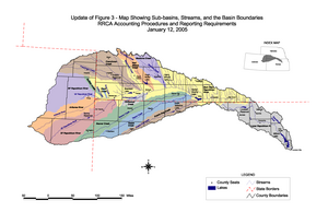
Map of the Republican River and its tributaries |
||
| Data | ||
| Water code | US : 485443 | |
| location | Nebraska , Kansas (USA) | |
| River system | Mississippi River | |
| Drain over | Kansas River → Missouri River → Mississippi River → Gulf of Mexico | |
| origin | The North Fork Republican River and Arikaree River meet in Dundy County 40 ° 1 ′ 12 ″ N , 101 ° 56 ′ 16 ″ W |
|
| Source height | 988 m | |
| confluence | with the Smoky Hill River at Junction City to the Kansas River Coordinates: 39 ° 3 '36 " N , 96 ° 48' 5" W 39 ° 3 '36 " N , 96 ° 48' 5" W |
|
| Mouth height | 318 m | |
| Height difference | 670 m | |
| Bottom slope | 0.92 ‰ | |
| length | 729 km | |
| Left tributaries | North Fork Republican River | |
| Right tributaries |
South Fork Republican River , Arikaree River |
|
| Reservoirs flowed through |
Swanson Reservoir , Harlan County Reservoir |
|
|
Flood on June 24, 1947 on the Republican River on the border of Jewell County and Republic Counties near Hardy and Webber . |
||
The Republican River is a river in the central Great Plains of North America . It flows 729 km through the US states of Nebraska and Kansas .
geography
The Republican River is formed by the confluence of the North Fork Republican River and Arikaree River north of Haigler in Dundy County . It unites with the South Fork Republican River southeast of Benkelman . All three tributaries have their origin in the High Plains of northeast Colorado . The Republican River flows mostly in an easterly direction along the southern border of Nebraska , flowing through the Swanson Reservoir and Harlan County Reservoir before turning south and entering the Smoky Hills region of Kansas . The Republican River joins the Smoky Hill River at Junction City to form the Kansas River .
Some places along the river include: McCook , Clay Center , Concordia, and Junction City . Near Concordia is the Republican River Pegram Truss , a bridge that spans the Republican River and is listed on the National Register of Historic Places .
history
The river was named after a tribe of the Pawnee Indians known as "the Republicans" (Stewart 1967: 223). The use of the water of the Republican River is regulated by an agreement between the states of Nebraska, Kansas and Colorado, the so-called Republican River Compact .
Individual evidence
- ↑ a b U.S. Geological Survey. National Hydrography Dataset high-resolution flowline data. The National Map . Retrieved March 25, 2011
- ^ North Fork Republican River ( English ) In: Geographic Names Information System . United States Geological Survey . Retrieved February 1, 2011.
- ^ South Fork Republican River ( English ) In: Geographic Names Information System . United States Geological Survey . Retrieved February 1, 2011.
- ↑ Arikaree River ( English ) In: Geographic Names Information System . United States Geological Survey . Retrieved February 1, 2011.
- ↑ Stewart, George R. (1967) Names on the Land . Boston: Houghton Mifflin Company.


