Smoky Hill River
| Smoky Hill River | ||
|
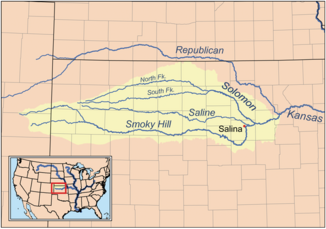
Catchment area of the Smoky Hill River |
||
| Data | ||
| Water code | US : 485314 | |
| location | Colorado , Kansas (USA) | |
| River system | Mississippi River | |
| Drain over | Kansas River → Missouri River → Mississippi River → Gulf of Mexico | |
| source |
Cheyenne County 38 ° 57 ′ 1 ″ N , 102 ° 34 ′ 49 ″ W. |
|
| muzzle |
Kansas River in Geary County Coordinates: 39 ° 3 '36 " N , 96 ° 48' 4" W 39 ° 3 '36 " N , 96 ° 48' 4" W. |
|
| Mouth height |
318 m
|
|
| length | 925 km | |
| Catchment area | 19,260 km² | |
| Discharge at gauge USGS 06877600, at Enterprise |
MNQ MQ MHQ |
38 m³ / s 1540 m³ / s 207,000 m³ / s |
| Left tributaries | North Fork , Saline River , Solomon River | |
| Reservoirs flowed through | Cedar Bluff Reservoir , Kanopolis Lake | |
| Medium-sized cities | Salina | |
|
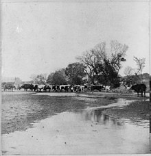
Smoky Hill River near Assaria |
||
The Smoky Hill River is a 925 km long river in the center of the Great Plains of North America . It flows in the US states of Colorado and Kansas .
Names
The Smoky Hill River owes its name to the Smoky Hills region in north-central Kansas through which it flows. The Aborigines of the Smoky Hills considered it and the Kansas River together as one river and named them Chetolah and Okesee-sebo . Early maps by European explorers named the river (in combination with the Kansas River) the River of the Padoucas , as its source is in the area known as "Padouca" ( Comanche Territory).
The USGS lists other name variants for the Smoky Hill River:
- Chitolah River
- Fork of the Hill Buckaneuse
- La Fourche de la Cote Boucaniere
- La Touche de la Cote Bucanieus
- Manoiyohe
- Pe P'a
- Sand river
- Shallow River
- Smoky Creek
- Branch de la Montagne a la Fumee
- Ka-i-urs-kuta
- Oke-see-sebo River
- Rahota katit hibaru
geography
The Smoky Hill River originates in the High Plains of eastern Colorado, from where it flows in an easterly direction. The main river and the North Fork Smoky Hill River have their source in Cheyenne County . Both streams meet about 3 miles west of Russell Springs in Logan County .
From there the river continues its course in a predominantly easterly direction through the Smoky Hills region. The Saline River , one of the two main tributaries, flows into the Smoky Hill River in eastern Saline County . The other major tributary, the Solomon River , meets the Smoky Hill River in western Dickinson County . The Smoky Hill River eventually reaches the Republican River at Junction City (Kansas) , with which it forms the Kansas River .
The Smoky Hill River drains an area of 19,260 km².
There are two reservoirs on the Smoky Hill River: Cedar Bluff Reservoir in Trego County and Kanopolis Lake in Ellsworth County .
The largest city on the Smoky Hill River is Salina . In addition to Junction City, the following places in Kansas are on the river: Ellsworth , Marquette , Lindsborg and Abilene .
Individual evidence
- ↑ a b National Hydrography Dataset, United States Geological Survey
- ↑ a b Water resources data for the United States, Water Year 2009; gage 06877600, USGS Smoky Hill River at Enterprise, KS (PDF; 64 kB)
- ^ Smoky Hill River. (2009). In Encyclopædia Britannica Encyclopædia Britannica Online
- ↑ Smoky Hill River, Kansas: a cyclopedia of state history, embracing events, institutions, industries, counties, cities, towns, prominent persons, etc. ( Memento of the original from June 16, 2008 in the Internet Archive ) Info: The archive link became automatic used and not yet tested. Please check the original and archive link according to the instructions and then remove this notice.


