
Reumannplatz
| Reumannplatz | |
|---|---|
|
|
|

|
|
| Basic data | |
| place | Vienna |
| District | Favoriten (10th district) |
| Created | 1872 |
| Confluent streets | Ettenreichgasse , Davidgasse , Rotenhofgasse, Buchengasse , Favoritenstraße , Wielandgasse , Herndlgasse , Puchsbaumgasse , Laaer-Berg-Straße , Bürgergasse , Neusetzgasse |
| Buildings | Amalienbad |
| use | |
| User groups | Pedestrians , bicycle traffic , car traffic , underground line U1 , tram lines 6 and 11 (in Quellenstrasse), bus lines 7A 65A 66A 68A 68B |
| Space design | park |
| Technical specifications | |
| Square area | approx. 27680 m² |
The Reumannplatz is for the public transport of important transportation hub in the 10th Vienna district, favorites .
location

Reumannplatz is located at the southern end of the Favoritenstrasse pedestrian zone . It has the shape of a triangle, with the pedestrian zone Favoritenstraße leading away from the northern corner, Favoritenstraße from the southeast corner towards Altes Landgut and Rothneusiedl and from the southwest corner Ettenreichgasse .
On the northern edge, the Buchengasse east-west connection touches Reumannplatz. (The Quellenstraße with tram traffic runs one block further north.) In the north-eastern area at Amalienbad, coming from the north, Wielandgasse and Herndlgasse end . To the east, Puchsbaumgasse , Laaer-Berg-Strasse and Bürgergasse branch off from the square (clockwise) . In the south, the short Neusetzgasse connects Reumannplatz with Antonsplatz , with the large Anton Church in the visual axis. Davidgasse and Rotenhofgasse branch off to the west .
In the middle of the square is a park that was divided by tram tracks until September 2017. Next to it there are two exits to the underground station, which was the southern terminus of the underground line U1 from 1978-2017 . The new U1 terminus at Therme Wien has been in place since September 2, 2017 . The U1 connects the square with the city center in just a few minutes. At the edges of the green area and next to and behind the Amalienbad are the end stations of the city bus routes 7A, 65A, 66A, 68A and 68B. The regional bus lines now have the Oberlaa bus station as the new terminus in Vienna.
history

The square was created in 1872 as a community square on the southern edge of what was then the 4th district or the city of Vienna at the historic fork of Laaer Straße (today Laaer-Berg-Straße ) and Himberger Straße (today Favoritenstraße ). The name had already been fixed in 1864. What was remarkable about its layout was the shape, because from the Bürgerplatz streets and alleys went in a star shape in all directions, which broke through the otherwise prevailing grid structure of Favoriten. In 1874, Favoriten was constituted as the new 10th district and expanded to include the neighboring Antonsplatz and its surroundings, which until then had been part of the municipality of Inzersdorf . In 1892 the district in the south reached as far as the Donauländebahn , so that the square was now part of the district center.
At the beginning, the square was only built on the north-eastern edge , apart from the Rote Hof , which is located in the area where the Rotenhofgasse and Buchengasse meet today and was built around 1803 . The planned blocks of houses in the area were already fixed. The square was given a new accent at the end of the 19th century when the large Anton Church, clearly visible from the Bürgerplatz, was built between 1896 and 1901. At that time, Gründerzeit apartment buildings were also built on the square. The dominant building was to be the Amalienbad, begun in 1923 and opened in 1926, on the eastern edge of the square. In 1925, the year of the death of Mayor Jakob Reumann , the city's first social democratic mayor, the square was renamed Reumannplatz.
After the Second World War, undemanding residential buildings were built at the junction with Favoritenstrasse. The square got its current shape until 1978, when the subway was built and Favoritenstrasse was converted into a pedestrian zone. As a result, Reumannplatz became one of the busiest transport hubs for local public transport. In addition, the Tichy ice cream parlor located here gained national fame. At Laaer-Berg-Straße 1–3 there is a higher education institution for business professions .
On September 2, 2017, the U1 subway line was extended south to Oberlaa from its southern terminus under Reumannplatz, which had been in service since 1978 .
Important buildings
Under and on the square
The Reumannplatz underground station opened in 1978 and was the southern terminus of the U1 line until September 1, 2017 . On September 2, 2017, the U1 was extended by five stations and since then has led to the Oberlaa underground station , where the 67 tram, which was then replaced by bus lines due to the construction of the underground in the south-eastern section, ran from 1974 to 2014 .
A memorial for the victims of fascism , which was created by Heinrich Sussmann and unveiled on October 24, 1981, is located in a central location in the green area of the square . It records the sites where the residents of Favoriten were victims of political persecution between 1934 and 1945. Tram vehicles could be seen in the square until September 2017.


No. 13, 14 and 15: apartment buildings
The last Wilhelminian-style apartment buildings from the end of the 19th century with an additive structure are located here. The Tichy ice cream parlor is located here at number 13 in a large corner bar on Rotenhofgasse 2.
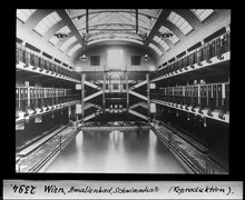
No. 23: Amalienbad
The Amalienbad , built between 1923 and 1926, was one of the largest indoor swimming pools in Europe when it was built. It is the architecturally most remarkable and dominant building on Reumannplatz.


_Wien10_Reumannplatz23_Amalienbad.JPG)


Individual evidence
- ↑ Electronic city map of the city administration
- ^ Street baptism , in: Daily newspaper Die Presse , Vienna, March 9, 1864, p. 4
- ^ Nachkriegsjustiz.at - Memorial Reumannplatz
literature
- Dehio Handbook Vienna. X. to XIX. and XXI. to XXIII. District . Anton Schroll, Vienna 1996
Web links
Coordinates: 48 ° 10 ′ 26.3 " N , 16 ° 22 ′ 42.4" E