
Favoritenstrasse


The Favoritenstraße is a major business and arterial road in the 4th Vienna district, Wieden , and in the 10th district, favorites .
history


A way from historic Vienna to the south
The Favoritenstraße was and is next to the Wiedner Hauptstraße the most important arterial road of the 4th district to the south. While the route has led via Wiedner Hauptstrasse and Triester Strasse to Wiener Neustadt and subsequently to Italy since the Middle Ages , one got to Hungary via Favoritenstrasse in a south-easterly direction. Its original name was Wimpassinger Weg (after the old Hungarian border town of Wimpassing an der Leitha on the way to Ödenburg ), after the construction of the imperial pleasure palace Favorita in today's 4th district it was called Kaiserweg .
At the beginning of the street on the city center side, building was built more densely as early as the 17th century, then the street continued as a dirt road to the Favorithen-Thor, where there was again a smaller group of houses with a chapel. The name Favoriten Linien Strasse appears on Vasquez's Vienna map from 1830 (line = gate in the line wall, a tax boundary). In the 19th century the character of the street changed due to numerous buildings from the Wilhelminian era. Opposite the former Favorita summer residence, which now housed the Theresian Academy , an elite school, it was an elegant residential area around 1900. In 1903 the Himberger Straße was included in the Favoritenstraße from the Wiedner Gürtel and the later Südtiroler Platz (which interrupts the house numbering of the Favoritenstraße) up to the city limits at the Donauländebahn . The old name has remained south of the railway to this day.
A little further away from the street in the 10th district at Keplerplatz, which also interrupts the numbering of the houses on Favoritenstrasse, on the western edge of the road at the intersection with Gudrunstrasse is the Keplerkirche , for a long time the only church in Favoriten. One block further south, a market square was built after 1870 (also on the western edge of the road), named Viktor-Adler-Platz since 1919 ; he too interrupts the house numbering on Favoritenstrasse. The Viktor-Adler-Markt is still located on the square today .
The Reumannplatz interrupts the favorites Street at the southern end of today's pedestrian zone. The Amalienbad , a municipal indoor swimming pool, was opened there in 1926 . Opposite is the Tichy ice cream parlor, which has been known beyond the district since 1955 .
The Per-Albin-Hansson settlement with the components west, north (both west of the road) and east was built in 1947–1977 on the southern slope of the Laaer Berg on areas previously used for agriculture . It includes more than 6000 municipal social housing. In 1959, the Laaerbergbad , a large urban summer pool, was opened immediately south of the hilltop .
In 1970, instead of the junction of Favoritenstrasse with Grenzackerstrasse and Ludwig-von-Höhnel-Gasse on a hilltop of the Laaer Berg, the favorites were created with accesses to the city freeway known as the Südosttangente , Austria's busiest road, and to the Laaerbergbad. Since 1981 this traffic area has been officially known as the Altes Landgut .
From 1974 a large pedestrian zone was built between Columbusplatz and Reumannplatz in the 10th district, making this section the lively center of the district. The section from the Gürtel to Columbusplatz was later included and the tram line O that remained here was moved to the parallel Laxenburger Straße.
The Vienna Central Station, completed in 2015, is located directly at the intersection of Favoritenstrasse and the Gürtel at Südtiroler Platz .
Public transportation
The first public transport to reach Favoritenstrasse was a horse-drawn tram line, opened in 1873, from Schwarzenbergplatz via Lothringerstrasse, past the Karlskirche into Karlsgasse and through Gusshausstrasse to Favoritenstrasse, where the horse-drawn tram went to Keplerplatz, then turned into Gudrunstrasse and ended after the intersection with Laxenburger Strasse at Jagdgasse. In 1889 this line was extended from Keplerplatz through Favoritenstraße to Angeligasse (four blocks south of what would later become Reumannplatz) at what was then the Altes Landgut inn .
In 1899/1900, the line from the beginning of Favoritenstrasse in the city center to Angeligasse was electrified. In 1908 the line was extended to Lehmgasse (at what is now the Favoriten district ), in 1914 it was extended to the southern end of Favoritenstrasse, until 1938 the city limits on the Donauländebahn . Trains on line 67 then ran from the Ring, Oper , to Lehmgasse, trains on line 167 to the terminus Rothneusiedl , Donauländebahn.
With the construction of Vienna's first underground line, the U1 , under Favoritenstraße, which opened in 1978, there was no longer any tram traffic in the street in the 4th district and from Columbusplatz to Quellenstraße in the 10th district since 1971. The Taubstummengasse , Südtiroler Platz , Keplerplatz and Reumannplatz train stations , the southern terminus until September 2, 2017, are located directly below Favoritenstraße. A diversion was put into operation for the tram from 1971–1978, which led in the 4th district through Graf-Starhemberg-Gasse, in the 10th district through Laxenburger Strasse and Schröttergasse via Antonsplatz to the outer Favoritenstrasse.
1974 took place in the newly created spa Oberlaa Vienna International Garden Show held at the same time was Oberlaa opened. On this occasion, line 67 was extended from Favoritenstrasse in Rothneusiedl to the Oberlaa spa center.
The tram line 67 was shortened in 1978 in the Favoritenstraße in the direction of Kurzentrum Oberlaa on the Quellenstraße – Rothneusiedl section. The station in the Favoriten distribution circle was named Altes Landgut . The 67er runs from Quellenstrasse via Laxenburger Strasse, Troststrasse and Neilreichgasse etc. to the terminus at Otto-Probst-Platz .

With the southern extension of the U1 underground line from Reumannplatz, 1978-2017 terminus, to Oberlaa (with the Therme Wien ), which opened on September 2, 2017, tram traffic in Favoritenstrasse has been completely eliminated. The new Troststraße , Altes Landgut and Alaudagasse underground stations have been built under the street .
Location and characteristics
With a length of 5.7 km and with 262 as the highest house number, Favoritenstrasse is one of the longest streets in Vienna. It is part of the B16 called Ödenburger Straße . The Favoritenstraße begins in the 4th district near the city center at Wiedner Hauptstraße and continues uphill over the Südtiroler Platz and the Wiedner Gürtel to the 10th district, where it touches Columbusplatz , Keplerplatz, Viktor-Adler-Platz and Reumannplatz , by the old estate reaches its apex on Laaer Berg and from there leads downwards in the direction of Rothneusiedl to the Donauländebahn , where it continues in Himberger Straße .
The Favoritenstrasse is of great importance for both car traffic and public transport. Its connection to the Gürtel and Südosttangente is important for car traffic, and above all for public transport the U1 underground line , which runs from the beginning of the street almost to the Donauländebahn; the extension from Reumannplatz there went into operation on September 2, 2017, and tram line 67 in Favoritenstrasse was discontinued.
At Südtiroler Platz, Vienna's new central train station was completed by 2015 . Favoritenstraße is the pedestrian zone and business center of the 10th district between the Gürtel and Reumannplatz. South of the Altes Landgut subway station in the Favoriten district is the Per-Albin-Hansson-Siedlung, one of the largest residential areas in Vienna, on both sides of Favoritenstrasse.
Significant structures


The Favoritenstraße begins as a junction from the Wiedner Hauptstraße at the Paulanerkirche and a free space in front of the church, today called Irene-Harand-Platz.
Since the even house numbers on the western side and the odd ones on the eastern side of the street are seldom directly opposite, the district number was given for houses near the district boundary 4/10 (which runs on the northern edge of the southern railway line). Südtiroler Platz, Keplerplatz, Viktor-Adler-Platz and Reumannplatz are crossed by the street and their house numbers interrupt the numbering in Favoritenstrasse.
No. 2: Former Paulan monastery
Until its abolition in 1783/84 the monastery building of the Paulaner order was located here . In 1802, the country coachman Joseph Neumann (1764–1849), who was a member of the Outer Council of the City of Vienna, had Franz Wipplinger build a four-story house at this point . This is a good example of the classicist residential building in Vienna. Above the entrance there is a relief with coats of arms-bearing genii.
No. 4 and 6: Late Historicism
In 1911 the architect Fritz Bretschneider built this large, late-historic building block with a rich structure and elaborate interior design.
No. 5: Electrotechnical Institute
The Wieden artillery barracks was located in the place of this Technical University building, which was built in 1973 from 1794 to 1843 . The artillery field weaponry was then housed here until 1856. Then the house was used as a district court until 1916. The property remained undeveloped from 1916 to 1973.

No. 7: Palais Archduke Carl Ludwig
The Palais Archduke Carl Ludwig is a delightful little garden palace that is not visible from the street today, as it is a modern new building. The palace was built as a baroque castle in 1780 by Adalbert Hild and redesigned by Heinrich von Ferstel in 1872/1873. The addition of small side wings gave the impression of a court of honor. From 1961 it was the casino Le Palais .
No. 8: Formerly theater
In place of the August-Bergmann-Hof, in which there is a branch of the Vienna library , there was once the Johann-Strauss-Theater . It was built in 1908 by Eduard Prandl and run as a popular operetta theater with 1200 seats. After the Great Depression it was converted into a variety stage and a cinema in 1931, which was named Scala . 1945–1955 the building served as a theater for plays of political content that the Soviets (as the occupying power in the 4th district) were allowed to do. From 1948 to 1956 it was called Neues Theater in der Scala . Since the house, which was suspected of communism, did not receive any public subsidies, it soon had to cease operations. The unused building was finally demolished in 1959/1960.
In the years 1978–1981 an urban residential complex was built on the open space according to plans by Gerhard Krampf and Karl Schwanzer . It was named after the social democratic district politician August Bergmann (1906–1966). The complex comprises 61 apartments and has 7 floors along Favoritenstrasse and Paulanergasse. There are arcades on the street, and a plaque commemorates the former Johann Strauss Theater. The artist Kurt Spurey designed a concrete wall called Movement .


No. 11: Former Hotel Victoria
The Escape to Egypt house was built in 1835 and was a hotel called Victoria or Viktoria . In it lived Johann Strauss II some time after the death of his wife. The facade of the Guardian Angel Pharmacy on the corner of Taubstummengasse was designed by Ludwig Tremmel around 1930 . It has tile cladding, bulging majolica frames and majolica reliefs, while the interior is from the 3rd quarter of the 19th century.
For decades, the management of Wiener Stadtwerke - Verkehrsbetriebe - was located in houses No. 9 and 11 . Today both buildings are home to the Faculty of Computer Science of the Vienna University of Technology , which provided a striking decoration in the form of a huge metal label covering almost the entire facade:
- TU WIEN TECHNOLOGY FOR PEOPLE KNOWLEDGE
- DEVELOP OPERATING EXCELLENCE &
- CONVEYING COMPREHENSIVE COMPETENCE

No. 15: Theresianum
From the 14th century on there was a farmstead, which in 1615 came into the possession of Emperor Matthias . He had the courtyard demolished and a summer palace built in its place, which was called Favorita . Both the names Favoritenstraße and Favoriten for the 10th district of Vienna go back to this name . The castle was burned down in 1683 before the approaching Turks , but then rebuilt in 1687–1690 in a larger and more beautiful baroque style. It became a favorite stay for Emperors Leopold I and Joseph I , but also for Karl VI. who died here.
However, his daughter Maria Theresa decided on Schönbrunn Palace as a summer residence and left the Favorita to the Jesuits , who set up a school here to train the sons of the nobility. The facility was enlarged for this purpose. After the dissolution of the Jesuit order in 1773, the college was converted into the Theresian Academy and re-established in 1797 by Franz II . At that time, the classicist central projection at the entrance was also created. Today the Diplomatic Academy Vienna and a high school with boarding school are located here . At the entrance to the park in the back of there is a bust of the State Minister Anton Schmerling that Anton Dominik Fernkorn has created.
No. 18: Office building
1966–1968 the office building for the 4th district, the seat of the district administration Wieden (the municipal district office for the 4th and 5th district is located in the 5th district, Margaretenstrasse), was built here according to plans by the municipal building department.
No. 24: Secessionism
This secessionist apartment building was built in 1902 by the architect Franz Xaver Neumann junior . The decor of the building increases towards the top and becomes more plastic. There are colored glass windows in the stairwell.

No. 25: Apotheke zum Stern
In this corner building on Karolinengasse there is the "Apotheke zum Stern" with historical inscriptions on the portal.
No. 26: Formerly wooden courtyard barracks
Here, opposite the Theresianum (No. 15), there was once the wooden yard barracks , which served as a training barracks for the carting industry. In 1900 it was moved to Meidling and the old building was demolished.

No. 30 and 32
On both sides of Möllwaldplatz, these two houses were built in 1906/1907 as entrées to the otherwise closed square according to plans by Karl Riess . The symmetrically laid out buildings have geometrical decor in the forms of the Wiener Werkstätte .
No. 38 and 40: Bertha-von-Suttner-Hof
The Palais Czernin , which later became Palais Althan , was originally located on the area of this large residential complex . The important Biedermeier furniture factory Danhauser was located in the castle from 1822 to 1844 and was run by the painter Josef Danhauser after the death of his father in 1830. Thereafter, the Wiedner Hospital, newly built in 1848, was located on the site . The middle part of the former palace was used as a management building. The building was badly damaged in the Second World War and was demolished in 1956.
In its place, the Bertha-von-Suttner-Hof urban housing complex was built according to plans by J. Parzer from 1955–1957 . It owns 360 apartments on 23 stairs between Favoritenstrasse, Waltergasse and Graf-Starhemberg-Gasse. The partially six-storey, simply designed building blocks are surrounded by green areas with seating. In addition to a children's playground, there is also a kindergarten in the facility. The sculpture Die Waffen Down! by Siegfried Charoux from 1957. There is also a bear sculpture by Ferdinand Opitz and a mosaic mural Children's Games by Helene Hädelmayr -Graf.
No. 47: Memory of Jakob Eschenbacher
On the modern house there is a relief plaque by Franz Barwig the Younger , which reminds of the master saddler Jakob Eschenbacher (1749–1809). During the French occupation he had secretly buried a cannon in the garden of his house at 9 Favoritenstrasse, but had been denounced and was executed by the French for it. The act was interpreted as patriotic, but it can also have occurred out of the pursuit of profit.
No. 48: Secessionism
This secessionist apartment building was built in 1903 by Alois Schumacher . It has an idiosyncratic decor, consisting of girl masks and stylized garlands.
No. 50: Historicism
In this strictly historic, palais-like apartment building from 1882 by Ferdinand Dehm and Franz Olbricht , the entrance area with its load-bearing atlases is particularly striking.

No. 51: Former "Bahnorama"
On the northern edge of the 10th district, in place of the municipal Antonie-Alt-Hof (No. 49, 51, 53) from the post-war period, which had to give way to the construction work for the new central station , from 2010 to 2014 there was an observation tower called bahnorama from from which one could follow the construction work, and an information center. The tower was 67 meters high, making it the highest accessible wooden tower in Europe. The viewing platform, which was reached by elevator, was 40 meters high. 30 people were allowed on it. There was a café on the first floor. The cost of the structure was 4.2 million euros. The temporary structures were removed in 2016. (In memory of Antonie Alt, an alley in the new building area of the former freight station, in the Sonnwendviertel , was named after her.)
No. 62: Late Historicism
In 1893 Ernst Gotthilf built this late historical apartment building in the 4th district with neo-Romanist decor. The segment arch portal with wrought iron grille is particularly striking.

No. 64: Kolschitzky Monument
Coffee maker Franz Zwirina donated a sculpture by Georg Franz Kolschitzky for this house on the corner of Kolschitzkygasse in the 4th district in 1885 , who, according to legend, introduced coffee to Vienna in 1683. During the Turkish siege he is said to have taken on daring scouting tasks and only asked for a few sacks of coffee from the Turkish loot as a reward. The sculpture was created by Emanuel Pendl . It was attached to the house on the first floor.
Pedestrian favorites
As a result of the subway construction under Favoritenstraße, the formerly very busy area between Landgutgasse and Reumannplatz was redesigned into a pedestrian zone. With a length of 900 m and an area of 20,000 m², it is one of the largest traffic-calmed zones in Vienna. The design comes from the architects Wilhelm Holzbauer , Heinz Marschalek, Georg Ladstätter, Norbert Gantar and Manfred Stein and was realized in stages from 1974–1976. There are many apartments and also many business premises in the district. Because of the low altitude of the underground tunnel, it is not possible to plant trees in the pedestrian zone. There is a pedestrian underpass at Gudrunstraße (the crossing used to be secured with chains, but since people kept walking over it, a traffic light system was finally set up).
The zone was expanded in 2004/2005 from Landgutgasse to Südtiroler Platz. The older section between Landgutgasse and Reumannplatz was renovated from 2010 to Buchengasse.

No. 73 and 75: Formerly Tlapa fashion house
This traditional company was founded here in 1873 by the tailor Wenzel Tlapa from Bohemia (then at Himberger Straße 27). In 1947 Karl Vitaly became the owner of the company, which he had to rebuild after the war. At the end of the 1960s, the house was expanded and received its striking light metal facade based on plans by the architect Kurt Stiel. The company was closed at the end of January 2016.
No. 76: "Birthplace of the 10th District"
The inconspicuous house on the northern edge of the 10th district stands on a narrow piece of land directly at the fork of the street coming from the 4th district into Favoritenstrasse and Laxenburger Strasse . Johann Heinrich Steudel ran his restaurant in the previous building . As a local politician, Steudel proposed the establishment of the 10th district and achieved it in 1874. He then became the first district chairman of Favoriten in 1875.
No. 96: Formerly a school
In 1862, in the former house at Himberger Straße 30, the first school in Favoriten was opened. Originally it consisted of two classes for girls and boys. In 1866 the girls were transferred to their own school at 10 Columbusgasse. Both schools were in private homes; In 1871 the municipality of Vienna opened a public school building on Keplerplatz.
No. 106: memorial plaque Fritz Killer
The Wienerlied composer Fritz Killer lived in this house until his death in 1983. He wrote over 400 songs. In his memory, the Favoriten Mandolin Orchestra donated a plaque on the building.

No. 108: Kepler sculpture
At the corner of Keplerplatz No. 10 there is a sculpture depicting the astronomer Johannes Kepler .

No. 118: Domenig House
This striking reinforced concrete building was built by Günther Domenig for the Zentralsparkasse und Kommerzialbank Wien in 1975–1979 , which sparked heated discussions and received a great deal of attention. The facade made of Nirosta panels is arched several times. The former “Z” now operates as UniCredit Bank Austria AG and no longer uses this building itself.
No. 126: Formerly the first district office in Favoriten
The first district chancellery of the 10th district was located in this house. The formation of this district was approved in 1874, and Johann Heinrich Steudel was elected first district head in 1875.

No. 174: Relief decoration with putti
The five-storey apartment building was built in 1913 by Hugo Fürst. It has sparse relief decoration with putti. The entrance with a lavishly designed painted frieze depicting a craftsmen's parade in historical costumes is unusual.
No. 173 and 175: Beschornerkreuz
The original of the Beschorner Cross , actually a Trinity column, set up on the edge of the dirt road in 1679 , is in the Favoriten District Museum . In 1979 a copy was placed here.
Altes Landgut underground station / Favorites distribution group
The southernmost two houses of the classic development, No. 218 and No. 219A, are followed by the favorites distribution circle , in which the Altes Landgut underground station was opened in mid-2017 .
No. 226: FH Campus Wien
In the years 2008/2009, the architectural office Delugan Meissl built this new study building, in which the facilities of the University of Applied Sciences FH Campus Wien , which were previously divided into different locations , were combined. The building covers an area of 8,800 m² on six floors with 30 lecture halls, 35 seminar rooms, 90 function rooms such as laboratories and IT rooms, a ballroom and a library.
No. 239, 241, 250: Per-Albin-Hansson-Siedlung
The Per-Albin-Hansson settlement with its three components one of the largest (municipal) housing estates in Vienna with a total of more than 6,000 apartments. West of Favoritenstrasse, the Per-Albin-Hansson settlements West (with two-story row houses) and North as a garden city were built in 1947–1951, 1954/1955 and 1964–1971. On the eastern side of the street, the five times larger Per-Albin-Hansson-Siedlung Ost was built in 1966–1977 , which consists of large apartment blocks in spacious green areas. The Hansson Center with shops and social and cultural facilities such as the district museum Favoriten , the Olof-Palme-Hof and the Alaudagasse underground station , which opened in 2017, is located directly to the east of Favoritenstraße , one of the five new stations on the U1 line south of Reumannplatz .
gallery
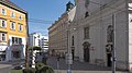
The beginning of the street at Wiedner Hauptstraße

At number 16

At the Theresianum (right)

At Karolinengasse
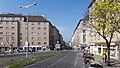
At Südtiroler Platz
At the Huppgasse

At Columbusplatz

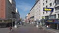
At No. 96

At Keplerplatz
At Erlachgasse

At the Viktor-Adler-Markt

At Buchengasse

At Reumannplatz (tram until September 2, 2017)

At Katharinengasse

At the Alaudagasse loop, which was closed on September 2, 2017

The end of the street at the railway station


Individual evidence
- ^ Walter Krobot, Josef Otto Slezak, Hans Sternhart: Tram in Vienna - the day before yesterday and the day after tomorrow , Verlag Josef Otto Slezak, Vienna 1972, ISBN 3-900134-00-6 , p. 299 ff
- ↑ Bertha-von-Suttner-Hof residential complex. Wiener Wohnen , accessed on May 19, 2015 .
- ↑ Courier: Viennese fashion house Tlapa locks ( Memento of the original from August 4, 2015 in the Internet Archive ) Info: The archive link was automatically inserted and not yet checked. Please check the original and archive link according to the instructions and then remove this notice. . Article dated July 31, 2015, accessed July 31, 2015.
literature
- Felix Czeike : Viennese district culture guide Wieden . Jugend & Volk, Vienna 1979
- Herbert Tschulk: Viennese district culture guide favorites . Jugend & Volk, Vienna 1985
- Felix Czeike: Historical Lexicon Vienna Vol. 2 . Kremayr & Scheriau, Vienna 1993
- Dehio Handbook Vienna. II. To IX. and XX. District . Anton Schroll, Vienna 1993
- Dehio Handbook Vienna. X. to XIX. and XXI. to XXIII. District . Anton Schroll, Vienna 1996
Web links
Coordinates: 48 ° 11 ′ 30.3 " N , 16 ° 22 ′ 16.1" E