Rhins of Galloway
The Rhins of Galloway , also Rhinns of Galloway , short The Rhins or The Rhinns (not to be confused with the peninsula Rhinns of Islay , also abbreviated ), is a peninsula in Scotland . Its name is derived from Gaelic roinn ( cape , projection) and the historical region of Galloway .
geography
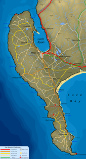
The almost hammer-shaped peninsula emerges from the land mass in the southwest of Scotland. Its north-south extension is around 46 km from the extreme locations of Corsewall Point in the north to the Mull of Galloway in the south. It is a maximum of around nine kilometers wide. The peninsula covers an area of around 310 km 2 . It is almost centrally connected to Great Britain by a 9.5 km wide isthmus . The part north of the isthmus is also known as the North Rhins of Galloway , the southern part as the South Rhins of Galloway . The Mull of Galloway marks the beginning of the North Channel , which runs along the west coast of the peninsula. On the east side, Luce Bay in the south and Loch Ryan in the north separate the Rhins of Galloway from Great Britain. The Mull of Galloway is the southernmost point of Scotland.
The Rhins of Galloway is sparsely populated. The most important places are Stranraer on the isthmus and Portpatrick on the north canal. There are no rivers on the Rhins of Galloway. Only numerous streams run through the peninsula. As part of the Central Lowlands , it has a flat elevation profile. With a height of 181 m, the top of the Cairnpat marks the highest point.
Administratively, the Rhins of Galloway is part of the Council Area Dumfries and Galloway . Historically, it belonged to the Galloway region or the traditional county of Wigtownshire .
traffic
Stranraer is the end point of the A75 coming from Gretna , which is part of the European route 18 . The A77 coming from Glasgow runs through Stranraer to Portpatrick. Leading south from the A77, the A716 connects the villages to Drummore with the road network. The A718 running north from Stranraer merges with the B738 in Kirkcolm. Formerly, ferries from Stranraer and Portpatrick connected the Rhins of Galloway with Belfast, Northern Ireland . However, these now operate from Cairnryan around ten kilometers northwest of Stranraer.
Attractions
On the Rhins of Galloway there are various buildings of the highest Scottish monument category A. These are the lighthouses Corsewall Lighthouse and Mull of Galloway Lighthouse , the southernmost building in Scotland. In addition, the Tower Houses Dunskey Castle , Galdenoch Castle , Stranraer Castle and Lochnaw Castle . In addition to the mansion Logan House also has Logan Windmill classified as Category A building. In addition, the two church buildings Old Parish Church of Kirkmaiden and Portpatrick Old Parish Church . Finally, the Stranraer Museum and the buildings 18-20 King Street monuments of category A are in Stranraer . Broch Doon Castle is also historically interesting .
Individual evidence
- ↑ a b c d Entry in the Gazetteer for Scotland
- ↑ a b c d Rhinns in: FH Groome: Ordnance Gazetteer of Scotland: A Survey of Scottish Topography, Statistical, Biographical and Historical , Grange Publishing, Edinburgh, 1885.
Web links
Coordinates: 54 ° 51 ′ 0 ″ N , 5 ° 3 ′ 0 ″ W.

