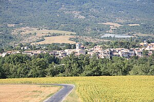
Ribiers
| Ribiers | ||
|---|---|---|

|
|
|
| local community | Val Buëch-Méouge | |
| region | Provence-Alpes-Cote d'Azur | |
| Department | Hautes-Alpes | |
| Arrondissement | Gap | |
| Coordinates | 44 ° 14 ' N , 5 ° 51' E | |
| Post Code | 05300 | |
| Former INSEE code | 05118 | |
| Incorporation | January 1, 2016 | |
| status | Commune déléguée | |
 Ribiers |
||
Ribiers is a former French commune with the last 811 inhabitants (2013) in the Hautes-Alpes in the region of Provence-Alpes-Cote d'Azur . It belonged to the arrondissement of Gap and the canton of Laragne-Montéglin . The residents call themselves the Ribierois.
With effect from January 1, 2016, the former municipalities of Antonaves , Châteauneuf-de-Chabre and Ribiers were merged into a commune nouvelle called Val Buëch-Méouge .
geography
Ribiers is located in the Maritime Alps at 519 m . In addition to the main settlement, there are also the hamlets of L'Adrech, La Flogère, Plaugiers, Franchironnette, Les Chabanons, La Marmotte, Les Autarets, Saint-Auberts and Les Eymarrons. The Buëch mountain river runs in the area just before it flows into the Durance .
Population development
| year | 1962 | 1968 | 1975 | 1982 | 1990 | 1999 | 2008 | 2012 |
|---|---|---|---|---|---|---|---|---|
| Residents | 485 | 481 | 533 | 592 | 637 | 677 | 777 | 895 |
