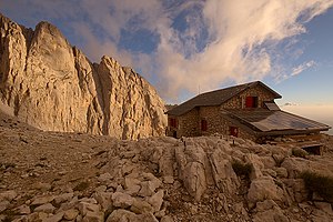
Rifugio Franchetti
| Rifugio Carlo Franchetti CAI refuge category C |
||
|---|---|---|
|
The Rifugio Franchetti at sunrise |
||
| location | Vallone delle Cornacchie; Teramo Province , Abruzzo , Italy ; Valley location: Pietracamela | |
| Mountain range | Gran Sasso d'Italia , Abruzzo Apennines | |
| Geographical location: | 42 ° 28 '37.4 " N , 13 ° 33' 54.3" E | |
| Altitude | 2433 m slm | |
|
|
||
| builder | CAI Section Rome | |
| owner | CAI Section Rome | |
| Built | 1960 | |
| Construction type | Refuge | |
| Usual opening times | Early June to late September | |
| accommodation | 22 beds, 0 camps | |
| Web link | rifugiofranchetti.it | |
The Rifugio Franchetti (full name Rifugio Carlo Franchetti ; German Franchettihütte ) is a refuge of the Rome section of the Italian Alpine Club CAI in the Gran Sasso massif in the Abruzzo Apennines . The hut, which is usually open from the beginning of June to the end of September, has 22 beds.
location
The hut, located in the Gran Sasso and Monti della Laga National Park at 2433 m asl , is the highest refuge in the Gran Sasso massif and the entire Apennines. It was built on a ridge of the glacier cirque called Vallone delle Cornacchie , which divides the cirque into two parts. The rifugio is about 40 minutes' walk below the remains of the Calderone Glacier, the only glacier in the Apennines . It is the starting point for the ascent of the Corno Grande and the Corno Piccolo. From the rifugio the view extends over the foothills of the Abruzzo Apennines to the Adriatic Sea .
history
The Rifugio, built from 1958 by the CAI Section Rome, was officially opened in 1960. It is named after the alpinist and speleologist Carlo Franchetti and not to be confused with the Rifugio near Cortina d'Ampezzo , which was also named after him until the beginning of the 1970s , and has since been known as the Rifugio Son Forca. The Rifugio Franchetti was last partially renovated in 2017.
Accesses
- From Prati di Tivo, 1450 m ⊙ on the unnumbered path to the La Madonnina mountain station, then on path 103 in 2 hours
- From the La Madonnina mountain station, 2015 m ⊙ on path 103 in 1 hour
- From Campo Imperatore , 2120 m ⊙ on path 101, 103 in 2 ½ - 3 hours
Crossings and neighboring huts
- To Rifugio Garibaldi , 2230 m ⊙ on path 103, 101 in 1 ½ hours.
- To the Rifugio Duca degli Abruzzi , 2388 m ⊙ on path 103, 161 in 2 hours.
- To Bivacco Bafile, 2669 m ⊙ on path 103 and via ferrata Bafile in 2 ½ hours.
literature
- Guida ai Rifugi del CAI. 375 Rifugi del Club Alpino Italiano per scoprire la montagna. RCS Mediagroup, Milan 2013.
- Stefano Ardito: I rifugi dell'Appennino centrale. 147 rifugi e bivacchi. Itinerari. Informazioni. Consigli utili . Iter Edizioni, Subiaco 2010, ISBN 978-88-8177-159-2 .
Web links
Individual evidence
- ↑ Un po di storia. In: rifugiofranchetti.it. Retrieved May 19, 2020 (Italian).
- ↑ Carlo Avoscan, Fabrizio Francescon (ed.): Rifugi della provincia di Belluno. Cenni storici, accessi, traversate, ascensioni alla ricerca delle creature più belle delle Dolomiti . Provincia di Belluno, Dosson di Casier 2006 p. 205

