
Campo Imperatore


The Campo Imperatore ( Italian for Imperial Field ) is a basin-shaped high plateau south of the Gran Sasso d'Italia massif in the province of L'Aquila in the Italian region of Abruzzo .
geography
The plateau was reached by a glacier formed and is close to the to the north side of Corno Grande located Calderone glacier , the southernmost glacier in Europe. Campo Imperatore is approximately 15 km long and 5 km wide and is part of the Gran Sasso and Monti della Laga National Park . The plateau is surrounded, among others, by the mountains Monte Prena , Monte Aquila , Monte Camicia and Monte della Scindarella , all with an altitude of over 2200 m.
The height of Campo Imperatore varies between 1500 and 1900 m and covers an area of approximately 80 km².
On the south-eastern flank of Campo Imperatore are the medieval mountain villages of Castel del Monte , Calascio and Santo Stefano di Sessanio , whose rulers were once the Medicis . In spring, summer and autumn, shepherds from these villages keep horses, cows and sheep unpenned in the meadows of the plateau . During this time, the pastures are covered with field grasses and meadow flowers.
The plateau is accessible from state road 17 to della Funivia del Gran Sasso e di Campo Imperatore, from which a junction leads to the parking lot of the mountain station of the Gran Sasso cable car.
Flora and fauna
Due to intensive pasture management in the past, it is estimated that between one and two million grazing animals lived around Campo Imperatore in the 16th and 17th centuries, the flora there has been exposed to strong changes. There was a general impoverishment of the species and massive occurrence of nitrophytes , such as great nettle , ring thistle , boar root , thistle , dandelion and other genera. Certain areas were populated by bristle grass , which is reviled by grazing animals and which also suffers little damage from the animals' hooves. The aristocratic pasture created by anthropogenic factors in turn forms a particularly valuable habitat type .
A botanical garden, founded in 1952 near the cable car station, is dedicated to the cultivation and research of around 300 native mountain plants. Among these plants are the rare and endangered bogberry , yellow gentian , edelweiss and adonis .
The Campo Imperatore is a habitat for the Italian wolf , wildcat and chamois . The Abruzzo chamois appeared to be almost extinct, but the population recovered thanks to intensive cooperation between the Italian WWF and the management of the national park. Other animal species that inhabit the plateau, are wild boar , fox , grass snake , the otherwise rare Orsini's viper and a variety of birds such as the golden eagle and hawk .

Flocks of sheep on the Campo Imperatore

Campo Imperatore from Monte Portella

The Corno Grande with the Vado Corno in front of it

Pasture landscape

Shepherd on the Campo Imperatore


.jpg)


history
Campo Imperatore has always been used as pasture, especially for transhumance . Transhumance already existed in pre-Roman times. During the occupation of Abruzzo by the Lombards from the second half of the 6th century, the formerly uniformly ruled area was divided between the two duchies of Spoleto and Benevento , which also brought transhumance to a standstill. With the conquest by the Normans between the 11th and 12th centuries, transhumance was resumed. The extensive pasture areas on Campo Imperatore also became the focus of interest. With the Hohenstaufen the area fell under the direct administration of the empire . The emperor gave it as a fief to local feudal lords and above all monks. In a feudal deed to the Cistercians signed by Frederick II from 1222, the monks were empowered to build the Grangie Santa Maria del Monte di Paganica on Campo Imperatore. In the period that followed, several grangia such as San Egidio or San Colomba del Monte Brancastelle were built on the plateau .
With the establishment of the sheep customs office ( Dogana delle pecore in Italian ) in the 15th century by the Aragonese , with which transhumance was regulated and the income from grazing rights taxed, transhumance experienced a significant impetus. It was then the Medici in particular who promoted the trade in wool. In the 16th century they came into the possession of the place Santo Stefano di Sessanio at the foot of the plateau and made the place a center of wool production. The rule of the Medici lasted until the 18th century. In the second half of the 19th century the slow decline of the wool trade began and with it the importance of transhumance on the Campo Imperatore. The result was that many residents in the places at the foot of the plateau emigrated.
Campo Imperatore experienced a new, this time tourist boom in the 1930s. In September 1934, at the instigation of the fascist mayor of L'Aquila and later party secretary of the National Fascist Party Adelchi Serena and his fascist counterpart from Pescara Giacomo Acerbo, the Campo Imperatore cable car from Fonte Cerretto was built on the western flank of the plateau. With the construction of the cable car, the town of Fonte Cerretto, the access road to the cable car, the Hotel Campo Imperatore near Pratorìscio designed by the architect Vittorio Bonadè Bottino and two ski lifts at the mountain station of the cable car came into being. With the construction, the Campo Imperatore ski area became a pioneer for winter sports in Italy, which benefited from its proximity to Rome .
Campo Imperatore gained notoriety through the liberation of Benito Mussolini in September 1943 through a German commando operation (code name company Eiche ), after Mussolini was imprisoned in the Hotel Campo Imperatore from the end of August to September after his fall in July 1943.
In 1947, cable car operations were resumed and the ski area expanded in the 1950s. In 1964 the cable car was modernized and in 1988 it was replaced by a new system. With the establishment of the Gran Sasso and Monti della Laga National Park in 1991, the Campo Imperatore plateau also became part of the National Park.
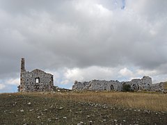
Ruins of the Grangie Santa Maria del Monte di Paganica
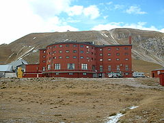
The Hotel Campo Imperatore designed by Vittorio Bonadè Bottino and opened in 1934
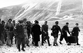
Mussolini, liberated at Campo Imperatore on September 12, 1943

Observatory and the Botanical Garden on Campo Imperatore

The various buildings at Pratorìscio
_-_Monastero_di_Santa_Maria_del_Monte_33.jpg)


.jpg)
.jpg)
Others
A branch of the Rome Observatory , the Stazione Osservativa di Campo Imperatore , was founded in 1952 and is located in the westernmost part of the plateau. Here the height and the lack of artificial light were exploited. The station has had the AZT-24 reflector telescope with a diameter of 1.1 meters since 1997 . The CINEOS ( Campo Imperatore Near-Earth Object Survey ) project is also operated here.
On the Campo Imperatore scenes were shot from about 20 international feature films, such as for Trinity Is Still My Name , Keoma , The Name of the Rose , Ladyhawke and night sun .
literature
- Maurilio Di Giangregorio: Campo Imperatore: storia di una stazione invernale . Litografia Brandolini, Sambuceto 2011.
- Luca Grazzini, Paolo Abate: Gran Sasso d'Italia. Guida dei Monti d'Italia . Club Alpino Italiano / Touring Club Italiano , Milan 1992.
See also
Web links
- Official website of the national park (Italian)
- Parco Nazionale del Gran Sasso e Monti della Laga
- Website about the national park
- Official tourism site of the Abruzzo region
Individual evidence
- ↑ Paolo Plini, Renato Napoli Vegetazione . In: Luca Grazzini, Paolo Abate: Gran Sasso d'Italia. Guida dei Monti d'Italia . Club Alpino Italiano / Touring Club Italiano , Milan 1992, p. 46.
- ↑ L'Habitat e le presenze vegetazionali. In: gransassolagapark.it. Gran Sasso and Monti della Langa National Park, accessed June 8, 2020 (Italian).
- ↑ Fabio Redi, Erika Ciammetti. Grance e mena delle pecore: rilevamento e valutazione dei siti pastorali d'altura a Campo Imperatore (AQ) . In: Francesca Sogliani, Brunella Gargiulo, Ester Annunziata, Valentino Vitale (eds.): VIII Congresso nazionale di archeologia medievale: Chiesa del Cristo Flagellato (ex Ospedale di San Rocco), Matera, 12-15 September 2018 . All'insegna del giglio, Sesto Fiorentino 2018, ISBN 978-88-7814-865-9 pp. 178-182.
- ↑ Cecilia Gallerani: Storia: la lana dei Medici. In: ppcalzelunghe.com. November 21, 2018, accessed May 27, 2020 (Italian).
- ^ Antonio Giampaoli: "Campo Imperatore, storia di una stazione invernale". In: assergiracconta.altervista.org. March 5, 2011, accessed May 27, 2020 (Italian).
- ↑ La storia. In: ilgransasso.it. Retrieved May 27, 2020 (Italian).
Coordinates: 42 ° 26 ′ 33 ″ N , 13 ° 33 ′ 33 ″ E