Beef ham
| Beef ham ( village ) | ||
|---|---|---|
|
|
||
| Basic data | ||
| Pole. District , state | Lienz (LZ), Tyrol | |
| Pole. local community | St. Jakob in Defereggen ( KG St. Jakob in Defereggen) | |
| Locality | Oberrotte | |
| Coordinates | 46 ° 54 ′ 41 ″ N , 12 ° 17 ′ 46 ″ E | |
| height | 1422 m above sea level A. | |
| Post Code | 9963 | |
| prefix | + 43/04873 | |
| Statistical identification | ||
| Counting district / district | St. Jakob in Defereggen (70724 001) | |
| Division of the parish of St. Jakob into groups | ||

|
||
| Source: STAT : index of places ; BEV : GEONAM ; TIRIS | ||
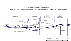
Rinderschinken is a village in the municipality of St. Jakob in Defereggen in the Austrian state of Tyrol, district of Lienz (East Tyrol). The place belongs to the Oberrotte fraction of the municipality and lies on the banks of the Schwarzach .
geography
The village of Rinderschinken, together with the hamlets of Ranach, Erlsbach and Grünmoos, the Rotten Mariahilf, Pötsch and Ladstatt, the individual farms Maik and Trogach as well as some alpine pastures and refuges, form what is known as the Oberrotte in the municipality of St. Jakob in Defereggen. Beef ham itself is located around 2.5 kilometers west of the community center between the right bank of the Schwarzach and the left bank of the Stallebach .
Sometimes the term beef ham is also used for the settlement on the left opposite the Schwarzenbach. However, this settlement is mainly referred to as Mariahilf.
history
At the beginning of the second half of the 16th century, all of the land used today was reclaimed, with the exception of the damp valley lowlands. In the course of the mining boom in Defereggental and the construction of a smelting works, mine workers settled in St. Jakob. Since the miners could not find a hostel in the village, they demanded the construction of Söll houses for their families. As a result, twelve Söll houses were built on the Schwarzach, which the locals referred to as the “city” due to the tight construction. The place name beef ham is explained in one work as follows: It “ is an indication of the poor grazing grounds in this area, as there was no possibility of keeping large cattle ”. The Söllsiedlung made it possible for the miners not only to acquire land, but also to provide for themselves by keeping goats.
In 1785 the Mariahilf Chapel was built in beef ham , a late Baroque chapel that was formerly a popular pilgrimage destination. In 1923, beef ham consisted of eleven houses with 39 residents; in 1951 there were 36 residents. In the following years the population remained relatively constant: in 1961 31 people lived in beef ham, in 1981 36 people lived in a total of thirteen houses, of which only nine were inhabited.
Individual evidence
- ↑ Statistics Austria (Ed.): Ortverzeichnis Tirol 2001. Wien 2005, p. 143
- ↑ Bundesdenkmalamt (Ed.): The art monuments of the political district of Lienz. Part III. Iseltal, Defereggental, Kalsertal, Virgental. Verlag Berger, Horn 2007 ISBN 978-3-85028-448-6 (Austrian Art Topography, Volume LVII), p. 256
- ↑ cf. For example, the Kompass hiking map No. 46 (Matrei in Osttirol, Kals am Großglockner)
- ↑ Söllhaus = a house for Söllleute , respectively (Söllmänner) in Tirol, "Gesellenhaus", "worker's house"
- ↑ Georg Jäger: Smallhouses and bell smiths, fruit dealers and pastors. On the tradition of rural businesses in Tyrol . Wagner, Innsbruck 2005, ISBN 978-3-7030-0409-4 .
- ↑ Bundesdenkmalamt (Ed.): The art monuments of the political district of Lienz. Part III. Iseltal, Defereggental, Kalsertal, Virgental. Verlag Berger, Horn 2007 ISBN 978-3-85028-448-6 (= Austrian Art Topography , Volume LVII), p. 255
- ↑ cf. the respective local directories

