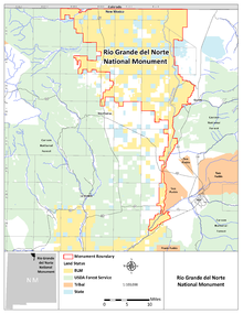
Rio Grande del Norte National Monument
The Rio Grande del Norte National Monument is an American national monument in the Rio Grande Gorge with Rio Grande in Taos County in northern New Mexico . The northern border of the reserve is also the border with Colorado . It was designated by President Barack Obama by a Presidential Proclamation on March 25, 2013 with an area of 242,555 acres (98,159 hectares ). The National Monument was designated because of the presence of endangered animal and plant species and important historical sites.
Administration and land ownership of the National Monument
The Rio Grande del Norte National Monument is under the administration of the Bureau of Land Management (BLM). The entire area is federally owned and was looked after by the BLM even before it was designated.
Private properties within the boundaries of the National Monument are not part of the protected area. These private properties can only become part of the National Monument if they can be freely acquired by the United States. If the federal government acquires private properties within the National Monument, these properties become part of the protected area. The designation of the National Monument has no influence on the rights of owners of properties that are not owned by the USA in or on the borders of the protected area.
The protection designation does not affect existing permits for grazing with livestock within the area and this may continue to be continued. The use of water rights in the protected area is also not restricted in the protected area.
Hiking, fishing, rafting , hunting, camping, bird watching, climbing, mountain biking, horse riding and other recreational uses are permitted in the protected area .
Except for emergency or approved administrative purposes, the use of motor vehicles in the protected area is only permitted on designated roads and paths.
Numerous roads including highways lead through the National Monument . This includes US Highway 285. US Highway 64 crosses the river over the 200 m high Rio Grande Gorge Bridge . The State Highway New Mexico Highway 570 and the Wild Rivers Backcountry Byway also run in the area.
Animal and plant species
Numerous species of birds, mammals, lizards, bats, insects and snakes can be found in the area. Mammal species in the area include bighorn sheep , pronghorn , mule deer , elk , Gunnison's prairie dog , red fox , coyote , North American catfish , bobcat , puma and black bear . The already exterminated North American otter was resettled. The protected area offers an important migration corridor for animal species between the two mountain ranges there.
The Río Grande del Norte is part of the Central Migratory Flyway , an important migratory corridor for birds such as the Canada goose , sandhill crane , herons, hummingbirds and avocets . The area is an important wintering area for birds. Year-round bird species live here as turkey , scaled quail , mourning dove , mountain plover and loggerhead shrike . The endangered Willow flycatcher ( Empidonax traillii ) also lives here. There are numerous species of birds of prey such as the turkey vulture , bald eagle and golden eagle .
In addition to rocky areas, there are large areas with sage steppe and grassland. Forests also grow in high areas. The cactus species Echinocereus triglochidiatus occurs in rocky areas of the gorge .
People in the area
The American Indians have inhabited this area for at least 7,500 years. Hundreds of petroglyphs are carved into the rocks and cliffs, ranging from seemingly abstract eddies and dots to clear depictions of people and animals. Dense clusters of petroglyphs are found near the hot springs that bubble in the deep heart of the canyon, some of which date back to archaic times. Many archaeological sites have been discovered. This ranges from the remains of pit houses , pot shards, tools and projectile tips to large ceramic vessels. Traces of the Indian tribes Jicarilla Apaches and Ute tribes were found. The Indians of the Taos Pueblo and the Picuris Pueblos also used the area. Newer artifacts and images mark the path of settlers and Hispanic explorers from the early 18th century. Abandoned ranches from the 1930s can also be found.
There are two BLM Visitor Centers in the Rio Grande del Norte National Monument . The Wild Rivers Visitor Center is located in the Wild Rivers Recreation Area near Questa. The Rio Grande Gorge Visitor Center is located in the Orilla Verde Recreation Area near Pilar.
Web links
Individual evidence
Coordinates: 36 ° 39 ′ 36 ″ N , 105 ° 42 ′ 0 ″ W.


